Key takeaways
- ✓The scheme is the Sunshine Coast Planning Scheme 2014, which commenced on 21 May 2014 and is amended over time.
- ✓Height is mapped. The Height of buildings and structures overlay sets a maximum for your specific site.
- ✓Development.i is the public search tool; MyCouncil is where applications are lodged.
- ✓Noosa Shire is a separate council with its own scheme — the 2014 scheme does not cover it.
- ✓The Maroochydore City Centre Priority Development Area is assessed by Economic Development Queensland, not Council.
Do You Need Council Approval on the Sunshine Coast?
You'll usually hear this called a development application, or DA — that's the formal name for council approval under the Planning Act 2016. On the Sunshine Coast, Council is the assessment manager for most of them, and the rules it applies come from the Sunshine Coast Planning Scheme 2014.
What makes this region distinctive is that two constraints most councils treat as secondary are front and centre: mapped building height, and the coast itself. A low-rise skyline is not an aspiration here, it is a mapped overlay with a number attached to your lot.
Get a council-ready planning report in 5 minutes — no planner, no waiting.
Get your report →The short answer
You need a development application when the Sunshine Coast Planning Scheme 2014 makes your work assessable for its zone, local plan and overlays. Plenty of minor domestic work is accepted development. Building approval is a separate decision, usually made by a private certifier rather than Council.
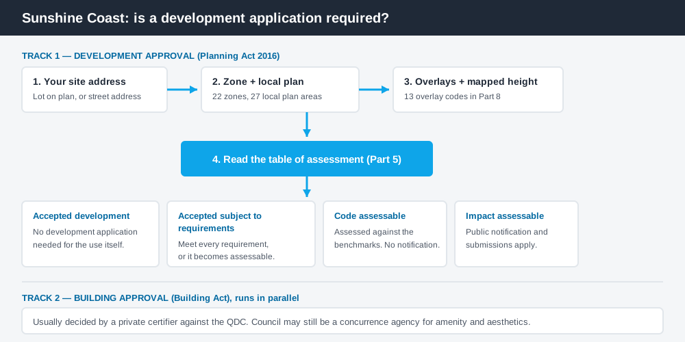
Figure 1: Two tracks run in parallel. Answering one does not answer the other.
The Sunshine Coast Planning Scheme 2014
Council adopted the scheme on 14 April 2014. It was gazetted on 2 May 2014 and commenced on 21 May 2014. Council describes it as a living document, amended from time to time, so the position you checked two years ago may have moved.
Structurally it follows the standardised Queensland framework with council-specific codes layered on top: Part 5 holds the tables of assessment, Part 6 the zone codes for 22 zones, Part 7 the local plan codes for 27 local plan areas, Part 8 the overlay codes for 13 overlays, and Part 9 the development codes.
That count of 27 local plans is worth pausing on. This is not one uniform ruleset stretched across the region — Caloundra, Maroochydore, Nambour, Maleny and the rural villages each have their own local plan code, and it can tighten what the zone otherwise allows. How to find out what zone your property is in covers reading zone, local plan and overlay together.
Two boundaries matter. Noosa Shire is a separate council with its own planning scheme; the 2014 scheme stops at the Sunshine Coast local government boundary. And the Maroochydore City Centre Priority Development Area is assessed by Economic Development Queensland under the Economic Development Act 2012, against a PDA development scheme — not by Council under the 2014 scheme.
Two approval tracks, not one
Spend 5 minutes, not 3 weeks
instantDA generates a council-ready planning report for Queensland development applications. No town planner. No waiting.
Get your report →Development approval is a Planning Act 2016 decision. Council is the assessment manager, and it deals with land use, siting, scale and compliance with the assessment benchmarks in the scheme.
Building approval is a Building Act decision about whether the structure complies with the building assessment provisions, including the QDC. It is usually given by a private certifier, not by Council.
They are separate approvals under separate legislation with separate decision-makers. A patio can be accepted development under the scheme and still require building approval; holding a building approval does not cure the absence of a development approval where one was needed. Building approval versus development approval sets out the distinction in full.
One local wrinkle sits between the two. Council has resolved that it is a concurrence agency for amenity and aesthetics for certain building work, including the permanent siting of shipping containers as a Class 10a building in some zones — so a container job routed through a certifier can still land back on Council's desk. Shipping containers and council approval covers the general position.
- ✓What is the zone and local plan?
- ✓Which of the 13 overlays apply?
- ✓What is the mapped height limit?
- ✓Is the work assessable or accepted?
- ✓Do you also need building approval?
- ✓Is the site inside the PDA?
Checking your own address
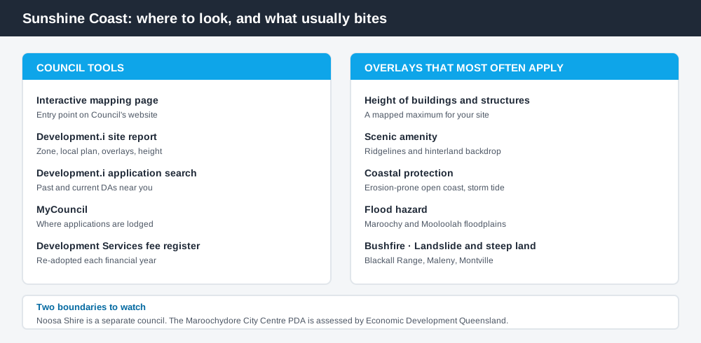
Figure 2: Council's tools, and the overlays that most often bite.
Council's interactive mapping page is the entry point. From there you can run a Development.i site report for a property, which pulls the planning layers together.
Development.i is also the public search tool for past and current development applications across the local government area. Looking at what has been approved on comparable nearby sites tells you what Council actually accepts and what conditions it attaches — often more useful than reading the code cold. Lodging through Development.i explains the system generally; on the Sunshine Coast, applications themselves are lodged through Council's MyCouncil service.
What catches Sunshine Coast owners out
Mapped height. The Height of buildings and structures overlay assigns a maximum height to individual sites, and a local plan or use code can impose something lower again on part of a lot. Assuming a district-wide figure applies to you is the most common and most expensive error here. Building height rules covers how height controls work.
Scenic amenity. A separate overlay protects views to and from the region's ridgelines and the hinterland backdrop. It bites hardest on the Blackall Range and the slopes above the coastal plain.
The coast and the rivers. Coastal protection and flood hazard overlays cover erosion-prone open coast, storm tide inundation, and the Maroochy and Mooloolah floodplains. Two guides are relevant: coastal hazard overlays and storm tide and coastal development.
Hinterland bushfire and steep land. Around Maleny and Montville, the bushfire hazard and the landslide hazard and steep land overlays frequently apply to the same lot.
When you will probably need a DA
Work that changes the use of a property, adds a dwelling, subdivides, exceeds the mapped height, or sits within a coastal, flood, bushfire or scenic amenity overlay is likely to be assessable. Modest domestic work on an unconstrained suburban lot is far more often accepted development, subject to any requirements attached to that acceptance. The only reliable answer comes from the table of assessment for your defined use, read against your zone, local plan and overlays.
What to do next
Run the Development.i site report, write down every overlay and the mapped height, then read the table of assessment for what you actually intend to build.
Council fees are published annually in its Development Services Register of Cost-recovery Fees and Commercial Charges. In the 2026/27 register, a material change of use for a Dwelling House is $980. Figures are re-adopted each year, so confirm the current register before budgeting.
If you'd rather see the zone, local plan, overlays and likely category of assessment for a Sunshine Coast address in one place, an instantDA planning report does that for $169 — against the $800–$1,500 a town planner typically charges for a preliminary opinion. You can start a report in a few minutes.
Then confirm with Council. One more thing worth knowing: Council is preparing a proposed new planning scheme to replace the 2014 scheme. Formal consultation ran from 15 July to 19 September 2025 and drew around 4,600 submissions. It has not been adopted, so the 2014 scheme still governs your application.
Frequently asked questions
What is the Sunshine Coast planning scheme?
Does the scheme cover Noosa?
How do I check the zoning and overlays for my property?
Who assesses development in the Maroochydore City Centre?
Is building approval the same as council approval?
Ready to generate your report?
Skip the writing. Get a council-ready planning report in 5 minutes.
Get your report