Key takeaways
- ✓Townsville's planning scheme is the Townsville City Plan, Version 2025/01, effective 8 December 2025.
- ✓The scheme contains nine overlays. Flood hazard and coastal environment are the two that bite most often.
- ✓Townsville sits in a tropical cyclone region, so some structures exempt elsewhere still need a building permit here.
- ✓Development approval and building approval are separate. A private certifier handles the building side.
- ✓Land in the Townsville City Waterfront Priority Development Area is assessed under a separate scheme, not the City Plan.
Do You Need Council Approval in Townsville?
You'll usually hear this called a development application, or DA — that's the formal name for council approval under the Planning Act 2016. In Townsville, Council is the assessment manager for most of these, and the rules it applies come from the Townsville City Plan.
What makes Townsville distinctive is the physical setting. The city is built on the floodplains of the Ross and Bohle Rivers, fronts a coastline exposed to storm tide, and sits inside a tropical cyclone region — which changes the building rules, not just the planning ones. Those facts shape more applications here than the zone does.
Get a council-ready planning report in 5 minutes — no planner, no waiting.
Get your report →The short answer
In Townsville, you need a development application when the Townsville City Plan makes the work assessable for your zone and overlays. Much minor domestic work is accepted development. Building approval is separate, usually issued by a private certifier, and the cyclone region means more structures need one here.
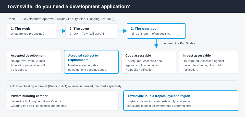
Figure 1: Two tracks run in parallel. Clearing one does not clear the other.
The Townsville City Plan
Townsville's local planning scheme is the Townsville City Plan, currently Version 2025/01, adopted 15 October 2025 and effective from 8 December 2025. It is kept current by amendment rather than replacement, so a copy downloaded a year ago may not be the one Council assesses against.
Like every Queensland scheme, it follows the standard state structure — strategic framework, zone codes, overlay codes and tables of assessment — with Townsville's own codes layered over it. Queensland schemes are not uniform, so a rule from a neighbouring council will not transfer. What zone is my property in covers that structure.
Council uses four levels: accepted development, accepted subject to requirements, code assessable and impact assessable. The second matters most to homeowners — comply with every acceptable outcome of the applicable code and no application is needed, but miss one and it generally becomes code assessable, meaning a DA. Accepted versus assessable explains that step change.
Two approval tracks, not one
Spend 5 minutes, not 3 weeks
instantDA generates a council-ready planning report for Queensland development applications. No town planner. No waiting.
Get your report →Development approval is a Planning Act 2016 decision. Council is the assessment manager, dealing with land use, siting, scale and compliance with the City Plan codes. Building approval is a Building Act decision about the structure itself, almost always issued by a private building certifier, not Council.
Council makes a point that is easy to miss: because Townsville is in a tropical cyclone region, structures may require higher standards of construction and material quality, and some structures exempt from a building permit in other regions — garden sheds and fences among them — need one here. Patios, carports, retaining walls over one metre and long-term shipping containers also generally need a permit. Building versus development approval covers the split.
If your work cannot meet the siting standards in the Queensland Development Code, Council also acts as a referral agency for siting relaxations and building over services — a separate application. Siting variations covers that.
- ✓What is the zone?
- ✓Which of the nine overlays apply?
- ✓Which assessment category applies?
- ✓Do you need a building permit under the cyclone rules?
- ✓Is a siting relaxation needed?
- ✓Is the site in the Waterfront PDA?
Checking your own address
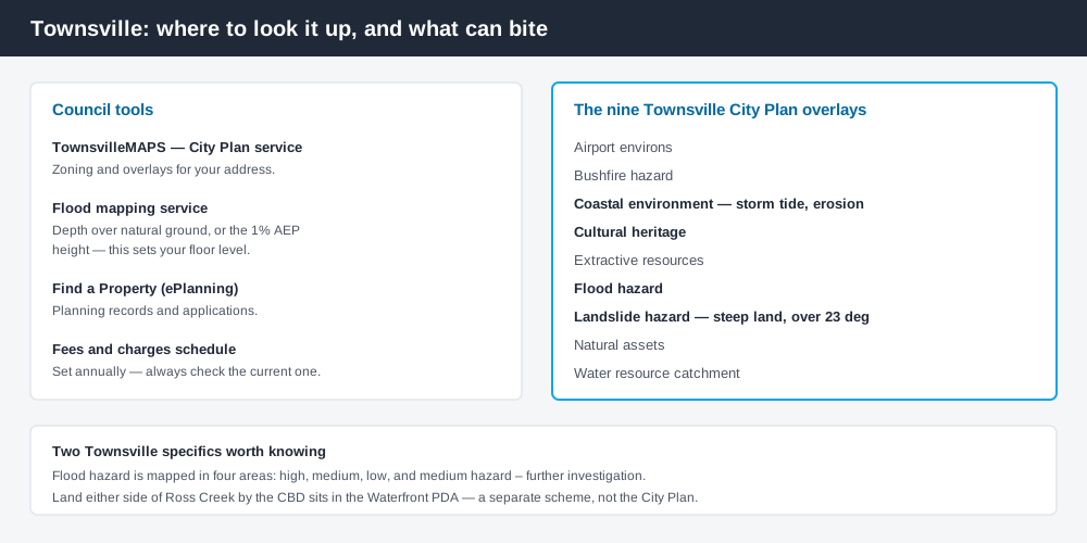
Figure 2: Four Council tools, each doing a different job.
Council runs TownsvilleMAPS, which includes a dedicated Townsville City Plan service for zoning and overlays plus separate Community and Flooding services. Its Find a Property tool returns planning records for an address, and a Flood mapping service gives the depth over natural ground or the 1% AEP height — which sets your floor level in a flood hazard area. For state layers, cross-check on the Queensland Globe.
What catches Townsville owners out
Flood. The flood hazard overlay maps four areas: high, medium, low, and medium hazard – further investigation. High and medium both represent the 1% AEP event, Townsville's defined flood event. A house in a medium hazard area is accepted subject to requirements — no application, provided you meet every acceptable outcome, including minimum floor heights. The February 2019 monsoon event, when record rainfall forced the Ross River Dam spillway gates fully open and thousands of Townsville properties were damaged, is why this mapping is taken so seriously. The flood hazard overlay covers the code.
Storm tide and the coast. The coastal environment overlay identifies storm tide inundation and erosion prone areas across the low-lying suburbs and the foreshore, and development should sit outside the erosion prone area. Council has identified an inner city area, including the CBD, where varied responses to those hazards are permitted. Storm tide and coastal hazard covers it.
Slope. The landslide hazard overlay catches steep land, with slope angles greater than 23 degrees flagged as a trigger for planning approval on a dwelling — relevant right around Castle Hill.
Heritage. Under the cultural heritage overlay, demolition or relocation of an identified heritage place is impact assessable, and even minor building work on one is code assessable.
Magnetic Island. The City Plan treats the island distinctly. Within the World Heritage listed Great Barrier Reef Marine Park, it is not envisaged to take significant additional growth, and accommodation is secondary to conservation values, with low-rise limits varying bay to bay.
The Waterfront PDA. Land either side of Ross Creek adjoining the CBD sits in the Townsville City Waterfront Priority Development Area, assessed against a separate scheme, not the City Plan.
Defence land. Commonwealth land such as Lavarack Barracks and RAAF Base Townsville is generally not regulated by a local planning scheme, though the airport environs overlay protects airport and RAAF operations from surrounding development.
When you will probably need a DA
Work that changes the use, adds a dwelling, subdivides, sits in the high or medium flood hazard area, falls in the coastal environment or cultural heritage overlay, or touches steep land is likely to be assessable. A shed, carport or garage on an unconstrained suburban lot usually is not, provided setbacks, site cover and height are met.
Council's 2026/27 fee schedule gives a sense of scale: an application where no more than two acceptable outcome provisions are not complied with for an accepted development subject to requirements use is listed at $918.00. Fees are set annually.
What to do next
Establish the zone and every overlay through TownsvilleMAPS, then read the Part 5 table of assessment for what you intend to do.
If you'd rather see the zone, the overlays and the likely category of assessment for a Townsville address in one place, an instantDA planning report does that for $169 — against the $800–$1,500 a town planner typically charges for a preliminary opinion. You can start a report in a few minutes.
Then confirm with Council's planning team before engaging a designer, particularly for anything in a flood, coastal or heritage overlay.
Frequently asked questions
What is Townsville's planning scheme?
Do I need council approval for a shed in Townsville?
How do I check flood mapping for my Townsville property?
Is a house in a medium flood hazard area assessable?
Ready to generate your report?
Skip the writing. Get a council-ready planning report in 5 minutes.
Get your report