Key takeaways
- ✓The scheme is the Winton Shire Planning Scheme, gazetted 28 February 2020 and commenced 2 March 2020. Version 3 took effect 20 November 2025.
- ✓There are four zones — Township, Rural residential, Rural, and Recreation and open space — with Commercial and Industrial precincts inside Township.
- ✓Building work is code assessable anywhere in the shire if the lot contains, or adjoins within 50m, a local heritage place.
- ✓Version 3 added a dark-sky lighting requirement to the General development code, and made it a condition of accepted development in the Township zone.
- ✓Winton township flood mapping uses a 1% annual exceedance probability event at 181.41m measured at the Flood Level Sign.
Do You Need Council Approval in Winton Shire?
You'll usually hear this called a development application, or DA — that's the formal name for council approval under the Planning Act 2016. In Winton, Council is the assessment manager, and the rules it applies come from the Winton Shire Planning Scheme.
Winton is a tourism shire in a way few Queensland local governments are. The scheme says so itself: it names paleo tourism, opal fossicking, film and nature-based tourism as economic pillars, and names the attractions — the Australian Age of Dinosaurs Museum, the Dinosaur Stampede National Monument at Lark Quarry, the Waltzing Matilda Centre, Bladensburg National Park, the Opalton field. Planning here is written around visitors.
In this guide: how the scheme works, the two approval tracks, how to check an address, and the two triggers that catch Winton owners out.
Get a council-ready planning report in 5 minutes — no planner, no waiting.
Get your report →The short answer
In Winton Shire you need a development application when the Winton Shire Planning Scheme makes your work assessable for its zone. A lot of minor work is accepted development — but heritage proximity and flood mapping change that. Building approval is a separate approval, usually from a private certifier.
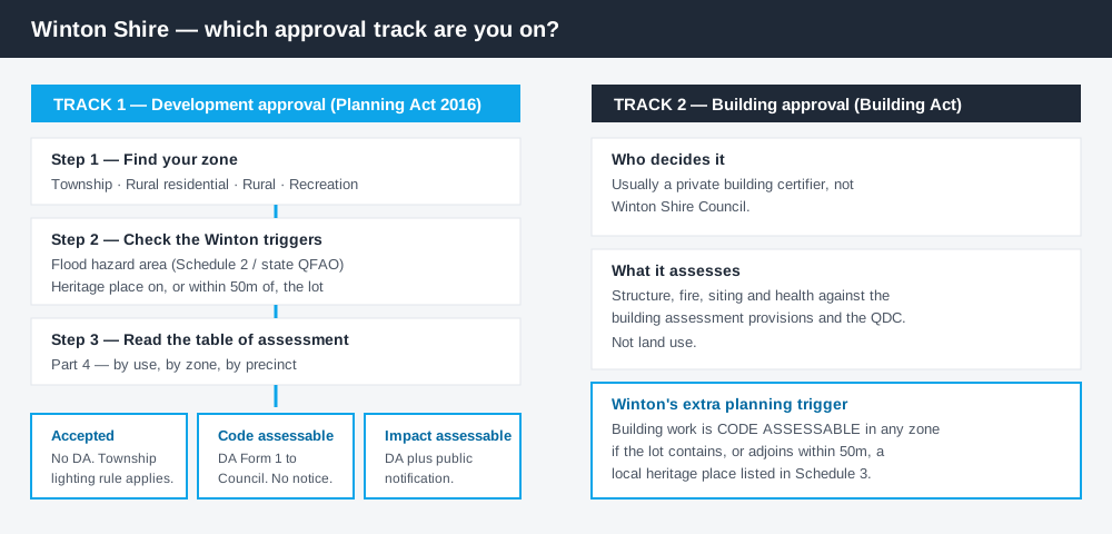
Figure 1: Two tracks run in parallel. Clearing one does not clear the other.
The Winton Shire Planning Scheme
The scheme may be cited as the Winton Shire Planning Scheme. Notice was published in Government Gazette No. 41 on 28 February 2020, and the commencement date was 2 March 2020. The current instrument is Version 3, adopted 20 November 2025.
It follows the standardised Queensland structure — strategic framework, tables of assessment, zone codes, development codes — but Queensland schemes share that structure, not their content, and Winton's is small. There are four zones: Township, Rural residential, Rural, and Recreation and open space. Two precincts sit inside Township: Commercial and Industrial. Three codes do the work — General development, Reconfiguring a lot, and Operational work. What zone your property is in covers reading that.
There are no overlay codes. Constraints arrive through the tables of assessment and Schedule 2 mapping instead.
Two approval tracks, not one
Spend 5 minutes, not 3 weeks
instantDA generates a council-ready planning report for Queensland development applications. No town planner. No waiting.
Get your report →Development approval is a Planning Act 2016 decision. Council is the assessment manager, and it deals with land use, siting, scale and compliance with the scheme's codes.
Building approval is a Building Act decision about whether the structure complies with the building assessment provisions, normally given by a private certifier. Building approval versus development approval sets out the distinction, and accepted versus assessable development explains the categories.
Winton adds an unusual wrinkle. Building work is code assessable under the planning scheme where the lot is or contains a local heritage place listed in Schedule 3, or shares a boundary with such a lot — unless no part of your lot is within 50 metres of it. That planning trigger sits on top of the certifier's job, and applies in every zone.
Checking your own address
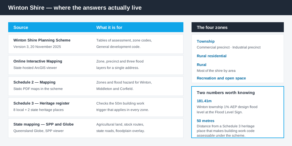
Figure 2: What Winton publishes, and what each source is actually for.
Winton does not run an ePlan platform or an online lodgement portal. Council links Winton Shire Planning Scheme Online Interactive Mapping, a state-hosted ArcGIS application, from its Planning Scheme page. It carries the zone layer, the precinct layer and three flood layers.
The scheme also publishes Schedule 2 mapping as static PDFs: zone maps for the shire and for Winton, Middleton and Corfield, plus flood hazard maps for each. Schedule 3 lists the local heritage places, so you can check the 50-metre building work trigger yourself. For state layers — agricultural land classification, the stock route network, state-controlled roads — cross-check the site on the Queensland Globe.
Applications go to Council directly on DA Form 1, so a call before you lodge is worth more here than in a city.
What catches Winton owners out
Heritage proximity. Schedule 3 lists eight local heritage places — the cemetery, the First Airfield, the Qantas Memorial in Elderslie Street opposite the North Gregory Hotel, the Willy Marrs vegetable store site, the War Memorial, the Shearers' Strike site at Red Creek Crossing, the Water Tower and the former Methodist church. Two state heritage places sit here too: the Corfield & Fitzmaurice Store and Elderslie Homestead. Adjoining any of them can make routine building work assessable. Heritage overlays explains how these layers behave.
Flood. Winton township sits on the Western River, and Middleton floods from Saville Creek. For the township the scheme adopts modelling for a 1% annual exceedance probability design event — 181.41m at the Flood Level Sign. For the rest of the shire it adopts the state Queensland floodplain assessment overlay. Being in a mapped flood hazard area elevates the level of assessment for many uses. Flood hazard overlays covers it.
Dark-sky lighting. Winton is Queensland's first International Dark Sky Community, 24 kilometres from The Jump-Up, Australia's first International Dark Sky Sanctuary. Version 3 of the scheme, effective 20 November 2025, inserted a dark-sky lighting provision into the General development code and made compliance a requirement of accepted development in the Township zone. External lighting that ignores it can move your project out of the accepted track.
When you will probably need a DA
Work that starts a new use, materially increases the intensity of an existing one, subdivides or realigns boundaries, involves excavation or filling, or sits in a mapped flood hazard area is likely to be assessable. Short-term accommodation is the live one here — the scheme actively encourages tourism development that value-adds to the drive-tourist routes, but it is a material change of use. Short-stay accommodation rules covers the category.
- ✓Which of the four zones?
- ✓Township precinct — Commercial or Industrial?
- ✓Within 50m of a Schedule 3 heritage place?
- ✓In the mapped flood hazard area?
- ✓Dark-sky compliant lighting?
- ✓Accepted, or assessable?
Council's 2026–2027 fees and charges set a minimum $295.00 lodgement fee for a code assessable material change of use, and $1,169.00 minimum for an impact assessable one. Subdividing one allotment into two carries no charge. Fees are reviewed annually with the budget, so confirm before you lodge.
What to do next
Get the zone and precinct from Council's online interactive mapping, check the same address against the flood layer and Schedule 3, then read the relevant table of assessment.
If you'd rather see the zone, the mapped constraints and the likely category of assessment for a Winton address in one place, an instantDA planning report does that for $169 — against the $800–$1,500 a town planner typically charges for a preliminary opinion. You can start a report in a few minutes.
Then call Council. Winton's Planning Scheme page has the current scheme, the mapping link and the fact sheets.
Frequently asked questions
What is Winton Shire's planning scheme?
Does Winton Shire have online planning maps?
How much does a development application cost in Winton?
Are there overlays in the Winton planning scheme?
Why does lighting matter in Winton?
Ready to generate your report?
Skip the writing. Get a council-ready planning report in 5 minutes.
Get your report