Key takeaways
- ✓The scheme is the Blackall-Tambo Region Planning Scheme 2020, which commenced on 24 January 2020.
- ✓It has only three zones: Township (with three precincts), Rural, and Recreation and Open Space.
- ✓The scheme carries no local overlay codes — flooding is handled through mapped flood layers instead.
- ✓Council publishes an online interactive map showing zones, precincts and the 1% AEP flood layers.
- ✓Development approval and building approval are separate. One does not substitute for the other.
Do You Need Council Approval in Blackall-Tambo?
You'll usually hear this called a development application, or DA — that's the formal name for council approval under the Planning Act 2016. In the Blackall-Tambo Region, Council is the assessment manager for most of these, and the rules it applies come from the Blackall-Tambo Region Planning Scheme 2020.
What makes this council distinctive is scale and simplicity. The region is large rural properties served by two townships, Blackall and Tambo, both on the banks of the Barcoo River. The scheme governing them is short by Queensland standards — three zones, one use code, no local overlay codes.
Get a council-ready planning report in 5 minutes — no planner, no waiting.
Get your report →The short answer
You need a DA when the Blackall-Tambo Region Planning Scheme 2020 makes the work assessable for your zone and precinct. A lot of ordinary rural and township work is accepted development. Building approval is a separate matter and is usually decided by a private certifier, not Council.
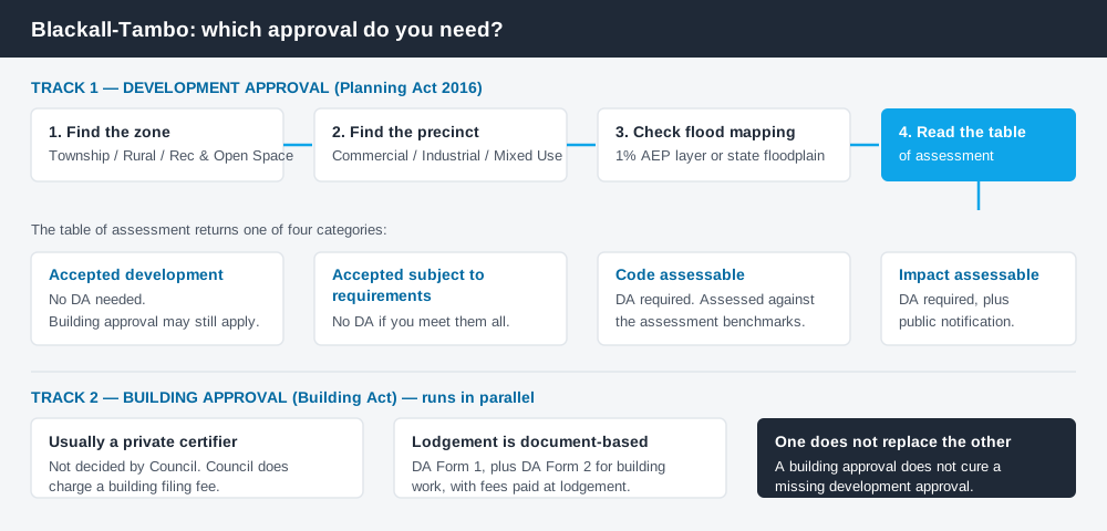
Figure 1: Two tracks run in parallel. Answering one does not answer the other.
The Blackall-Tambo Region Planning Scheme 2020
This is one consolidated scheme covering the whole region. It replaced the two legacy shire schemes — the former Blackall Shire and Tambo Shire planning schemes — which Council still publishes as superseded documents. A PDF saved from before 2020 describes a scheme that no longer applies.
The scheme may be cited as the Blackall-Tambo Region Planning Scheme 15 January 2020, with a commencement date of 24 January 2020. Like every Queensland scheme it follows the standard structure — strategic framework, zone codes, tables of assessment — but Queensland schemes are not uniform, and the local codes layered on that structure differ council by council. Here there are very few.
The scheme contains the Township zone with a Commercial precinct, an Industrial precinct and a Mixed Use precinct; the Rural zone; and the Recreation and Open Space zone. That is the complete list. There is one use code, the General development code, plus a Reconfiguring a lot code and an Operational work code. Heritage places sit in a schedule rather than an overlay.
Two approval tracks, not one
Spend 5 minutes, not 3 weeks
instantDA generates a council-ready planning report for Queensland development applications. No town planner. No waiting.
Get your report →Development approval is a Planning Act 2016 decision. Council is the assessment manager. It deals with land use, siting, scale and compliance with the codes in the scheme.
Building approval is a Building Act decision about whether the structure complies with the building assessment provisions. It is usually given by a private certifier, not by Council — though Council does charge a building filing fee and carries out plumbing inspections. Building approval versus development approval covers the distinction.
A machinery shed can be accepted development and still need building approval. Holding a building approval does not cure a missing development approval.
- ✓What zone and precinct is the land in?
- ✓Is it inside a mapped flood layer?
- ✓Is the work assessable, or accepted development?
- ✓Is it accepted subject to requirements?
- ✓Do you also need building approval?
- ✓Does it involve plumbing or a bore?
Checking your own address
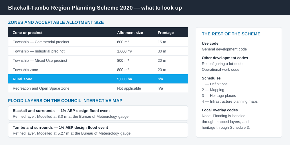
Figure 2: What Council's map actually shows you, layer by layer.
Council does have an online interactive map, listed in the scheme's online mapping resources and hosted as an ArcGIS web viewer. It carries the scheme zones and precincts plus the flood mapping layers. It is not a polished property-report tool of the kind the big south-east councils run — no address-based report generator, no council DA search portal — but it will tell you your zone.
The flood layers are the part worth knowing. Alongside the state's Queensland floodplain assessment overlay, which applies outside the refined areas, the map carries a Blackall 1% annual exceedance probability design flood layer and a Tambo equivalent. Cross-check state layers such as vegetation and stock routes on the Queensland Globe, and read how to check overlays for the method.
What catches Blackall-Tambo owners out
The Rural zone lot size. The scheme's acceptable outcome for allotment size in the Rural zone is 5,000 hectares. Township lots sit at 800 square metres, or 600 in the Commercial precinct. If you are thinking about carving a house block off a grazing property, that gap is the whole conversation. Minimum lot sizes and reconfiguring a lot cover what follows.
The Barcoo. Both towns sit on the river, and the design flood layers exist because flooding here is recurrent rather than theoretical. Being outside a refined layer does not put you outside the state floodplain mapping.
Artesian water. Both town supplies draw directly from the Great Artesian Basin via bores — Blackall was the site of the first artesian bore drilled in outback Queensland, in 1885 — and the scheme is explicit that development must not compromise their security and quality. If your project involves a bore, read bore and water licence requirements first.
Heritage. No heritage overlay, so people assume no heritage control. Schedule 3 lists local heritage places and separately records state heritage places, including the Blackall Woolscour, the Blackall Masonic Temple and the former Tambo Court House and Post Office. Development affecting a listed place is assessed against the scheme's heritage provisions regardless.
When you will probably need a DA
Work that changes the use of land, adds a dwelling, reconfigures a lot, involves material excavation or filling, or affects a listed heritage place is likely to be assessable. Ordinary rural infrastructure and modest township work on an unconstrained lot is more often accepted development, subject to any requirements attached to that acceptance. Building on rural land in Queensland covers the rural pattern.
Lodgement here is document-based, not portal-based: DA Form 1, plus DA Form 2 for building work, with supporting information and fees payable at lodgement.
What to do next
Establish your zone and precinct on Council's map, check whether either flood layer touches the land, then read the table of assessment.
Council's adopted fees and charges schedule for 2026/27 sets a lodgement fee of $742 for a development application for building work assessable against the planning scheme. Subdividing one allotment into two is $1,725. Both are re-adopted with the annual budget, so confirm current figures with Council.
If you'd rather see the zone, the mapped constraints and the likely category of assessment for a Blackall-Tambo address pulled together in one place, an instantDA planning report does that for $169 — against the $800–$1,500 a town planner typically charges for a preliminary opinion. You can start a report in a few minutes.
Then talk to Council. In a region this size the planning contact is a phone call rather than a queue, and for anything touching flood, heritage or a rural reconfiguration that conversation is worth having early.
Frequently asked questions
What is the planning scheme for Blackall-Tambo?
What zones does the scheme have?
Does the council have an online planning map?
How much does a development application cost here?
Do I need approval for a shed on a grazing property?
Ready to generate your report?
Skip the writing. Get a council-ready planning report in 5 minutes.
Get your report