Key takeaways
- ✓The scheme is the Burke Shire Planning Scheme 2020, adopted January 2020 and commenced 7 February 2020.
- ✓There are four zones — Township (Commercial, Industrial and Residential precincts), Recreation and open space, Rural residential, and Rural.
- ✓The scheme has no overlay codes. Flood comes from Schedule 2 mapping; bushfire and coastal hazard come from state mapping.
- ✓Filling or excavation inside a mapped flood hazard area becomes assessable operational work at just 150mm of fill or 10 cubic metres.
- ✓Council's adopted 2026-27 fees list a planning lodgement fee of $133 per application, with assessment on full cost recovery.
Do You Need Council Approval in Burke Shire?
You'll usually hear this called a development application, or DA — that's the formal name for council approval under the Planning Act 2016. In Burke Shire, Council is the assessment manager, and the rules it applies come from the Burke Shire Planning Scheme 2020.
Burke is one of Queensland's smallest local governments by population and one of the largest by area — roughly 40,000 square kilometres of Gulf country, with an estimated resident population of 438 in 2023. There are two settlements, Burketown and Gregory. Everything else is cattle station.
In this guide: how the scheme works, the two approval tracks, how to check an address, and what catches owners out here.
Get a council-ready planning report in 5 minutes — no planner, no waiting.
Get your report →The short answer
You need a development application in Burke Shire when the Burke Shire Planning Scheme 2020 makes your work assessable in your zone. A dwelling house in Burketown's Residential precinct is usually accepted development subject to requirements. Building approval is separate, and Council is contactable directly in Burketown.
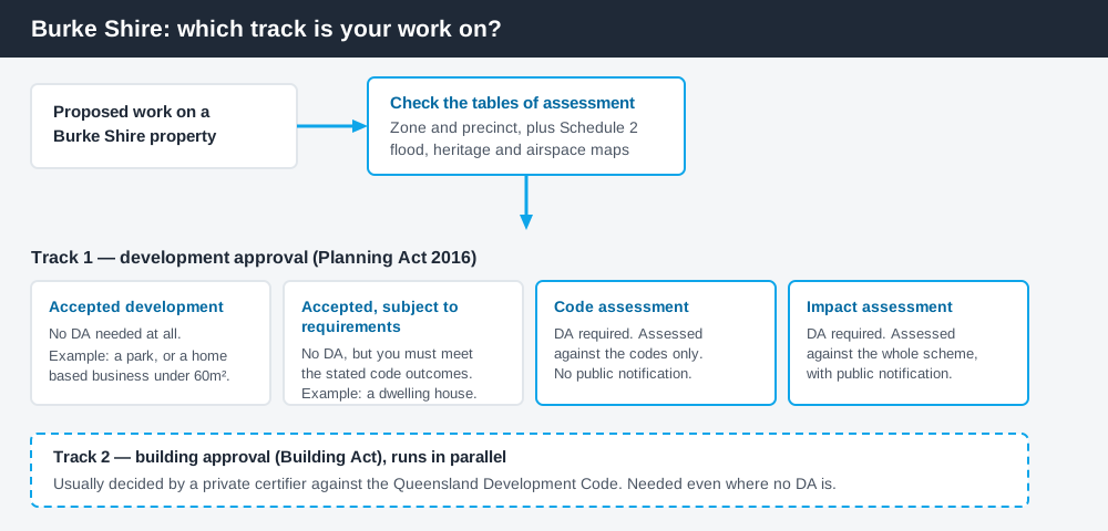
Figure 1: Two tracks run in parallel. Answering one does not answer the other.
The Burke Shire Planning Scheme 2020
Council adopted the scheme at its January 2020 meeting and it commenced on 7 February 2020. It was written to a twenty-year horizon and Council has not published a later numbered version.
Queensland schemes share a structure, not their content, and Burke's is lean. There are four zones: Township, carrying Commercial, Industrial and Residential precincts; Recreation and open space; Rural residential; and Rural. Almost the entire shire is Rural. Four codes do the rest: General development, Non-resident workforce accommodation, Operational work, and Reconfiguring a lot. Working out what zone your property is in is the first move.
No overlays — the constraints sit in Schedule 2
Spend 5 minutes, not 3 weeks
instantDA generates a council-ready planning report for Queensland development applications. No town planner. No waiting.
Get your report →The scheme has no overlay codes at all. Where a city scheme would send you to a flood or bushfire overlay, Burke's tables of assessment point straight at maps.
Flood runs through the flood hazard maps in Schedule 2, backed by Schedule 6, which sets defined flood levels for Burketown. Bushfire and coastal hazard work differently — the scheme sends you to State Planning Policy mapping. Parts of the shire fall inside the Queensland Coastal Management District and are exposed to erosion prone areas and storm tide inundation. Flood hazard mapping and storm tide and coastal hazard explain how those layers behave.
Two further triggers apply across every zone. Work on or within 50 metres of a place on Schedule 5, the local heritage register, is code assessable. So is anything intruding into the airport's operational airspace on maps BTN AF1 and BTN AF2 — a real constraint in a town where the airstrip is the wet season lifeline.
Two approval tracks, not one
Development approval is a Planning Act 2016 decision. Council is the assessment manager, dealing with land use, siting, scale and the scheme's codes.
Building approval is a Building Act decision about whether the structure complies with the building assessment provisions, usually given by a private certifier working to the Queensland Development Code. Different people, different rules, and one does not substitute for the other. Building approval versus development approval covers the distinction.
Council's guidance for building applications, permits and demolitions is to contact the office in Burketown. Its adopted 2026-27 fees list a lodgement fee of $133 per application for planning assessment, the same $133 to lodge a private certifier's building approval, and assessment on full cost recovery with a $500 deposit. Figures reset annually.
- ✓Which zone and precinct?
- ✓Flood hazard area on Schedule 2?
- ✓Bushfire or coastal on SPP mapping?
- ✓Within 50m of a heritage place?
- ✓Airport operational airspace?
- ✓Building approval too?
Checking your own address
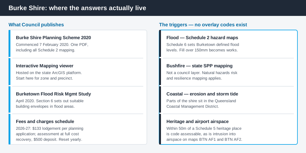
Figure 2: What Burke publishes, and what each source is actually for.
Burke does not run an ePlan platform. From its Planning page Council publishes the Burke Shire Planning Scheme 2020 (including maps) as a single document and links an Interactive Mapping viewer on the state's ArcGIS platform. That viewer is the practical starting point for zoning.
Council also publishes the Burketown Flood Risk Management Study, completed in April 2020 with the Queensland Reconstruction Authority. Section 6 identifies suitable building envelopes in flood-affected areas — read it before you commit to a slab level. For state layers, cross-check the site on the Queensland Globe.
What catches Burke owners out
Earthworks. Inside a mapped flood hazard area, filling more than 150 millimetres in height, or filling or excavating more than 10 cubic metres, becomes assessable operational work in every zone except Rural and the Township Industrial precinct. Building up a house pad clears that easily. Operational works explains the approval.
Sheds and containers as housing. The strategic framework openly supports shed and container housing as an affordable option where it suits local character — but "supported in principle" is not "no approval needed". Shipping container structures still have to clear the zone code and the building track.
Tourism. Burketown's visitor season runs on barramundi, the Savannah Way and the Morning Glory cloud that rolls in over the Gulf in September and October. Turning a house into visitor accommodation is a material change of use, and a tourist park in the Rural residential zone is code assessable.
Rural scale. Large holdings do not mean no rules. Reconfiguring a lot, clearing and extractive industry all engage the scheme — see building on rural land.
When you will probably need a DA
Work that starts a new use, intensifies an existing one, subdivides, moves earth inside the mapped flood hazard area, sits within 50 metres of a heritage place or rises into the airport's operational airspace is likely assessable. A dwelling house in the Residential precinct is accepted development subject to requirements, and a home based business under 60 square metres with no more than two employees on site is accepted development outright.
What to do next
Get the zone from Council's interactive mapping, check the Schedule 2 flood hazard maps for the same address, then read the table of assessment for what you intend to build.
If you'd rather see the zone, the mapped constraints and the likely category of assessment for a Burke Shire address in one place, an instantDA planning report does that for $169 — against the $800–$1,500 a town planner typically charges for a preliminary opinion. You can start a report in a few minutes.
Then call Council. In a shire this size a conversation with the office beats any amount of reading, and you need a fee quotation anyway. Council's Planning page holds the scheme and the mapping link.
Frequently asked questions
What is Burke Shire's planning scheme?
Does Burke Shire have online planning maps?
How much does a development application cost in Burke Shire?
Are there overlays in the Burke Shire planning scheme?
Do I need approval to fill my block in Burketown?
Ready to generate your report?
Skip the writing. Get a council-ready planning report in 5 minutes.
Get your report