Key takeaways
- ✓Carpentaria has published two schemes — the Carpentaria Shire Planning Scheme (May 2008) and the newer Carpentaria Planning Scheme 2024. Confirm with Council which one applies to your application.
- ✓The 2008 scheme has six zones and only three overlays: good quality agricultural land, aerodromes and aviation facilities, and acid sulfate soils.
- ✓The 2024 scheme adds the layers the Gulf actually needs — flood hazard, coastal hazard erosion, coastal hazard storm tide, bushfire and environmental significance.
- ✓Council no longer accepts development applications by email. They go over the counter in Normanton or by mail.
- ✓Council's 2025/2026 schedule charges a material change of use application at cost, with $1,200.00 charged up front.
Do You Need Council Approval in Carpentaria Shire?
You'll usually hear this called a development application, or DA — that's the formal name for council approval under the Planning Act 2016. In Carpentaria, Council is the assessment manager, and it applies its own planning scheme to your land.
Carpentaria is the Gulf. Two towns carry almost all the built development: Normanton on the Norman River, and Karumba where the river meets the Gulf of Carpentaria and the prawn and barramundi fleets tie up. Everything else is cattle country, and for months of the wet the roads between are closed.
Get a council-ready planning report in 5 minutes — no planner, no waiting.
Get your report →The short answer
In Carpentaria Shire you need a development application when the planning scheme makes your work assessable for its zone. Council is the assessment manager. Building approval is a separate approval from a private certifier. Applications are no longer accepted by email — they go over the counter in Normanton or by mail.
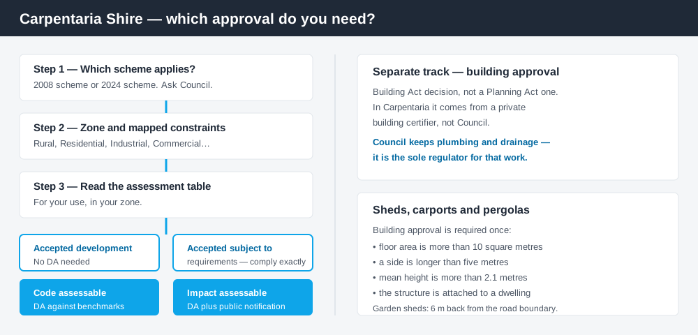
Figure 1: Two tracks run in parallel. Answering one does not answer the other.
Which scheme applies — this is the first question here
Most councils have one scheme. Carpentaria publishes two, and you need to know which governs your application before you do anything else.
The long-standing document is the Carpentaria Shire Planning Scheme, dated May 2008 and prepared under the Integrated Planning Act 1997 — the legislation that preceded the Planning Act 2016. Council still publishes it in full. Alongside it sits the Carpentaria Planning Scheme 2024, prepared under the Planning Act 2016 and the Minister's Guidance and Rules 2023. Council's page says the new scheme has been completed and will replace the 2008 scheme; that page was written while commencement was still pending and has not been rewritten since.
So: ring Council and ask which scheme your application is assessed under. Getting it wrong means you have read the wrong assessment table. Queensland schemes follow the QPP structure with council-specific content layered on top, and these two are not interchangeable.
Zones and overlays, old and new
Spend 5 minutes, not 3 weeks
instantDA generates a council-ready planning report for Queensland development applications. No town planner. No waiting.
Get your report →The 2008 scheme runs six zones: Rural, Rural Residential, Residential, Industrial, Community Infrastructure and Commercial. Almost the whole shire is Rural. The scheme itself notes that parts of Karumba have long carried a mix of industrial, residential and commercial uses, and that the mix is intended to continue.
The 2008 scheme carries only three overlays: good quality agricultural land, aerodromes and aviation facilities, and acid sulfate soils. Look at that list against where you are standing. There is no flood overlay and no coastal hazard overlay in it.
The 2024 scheme fixes exactly that. Its overlay maps cover acid sulfate soils, agricultural land, airport, bushfire, coastal hazard erosion, coastal hazard storm tide, environmental significance, flood hazard, regional infrastructure and road hierarchy. Its zone fact sheets use current names — General residential, Centre, Industry, Community facilities, Rural residential and Rural.
Two approval tracks, not one
Development approval is a Planning Act 2016 decision by Council about land use, siting, scale and the scheme's assessment benchmarks — material change of use, reconfiguring a lot and operational works.
Building approval is a Building Act decision about the structure itself, and in Carpentaria it comes from a private building certifier, not Council. Council's guidance is specific: sheds, carports and pergolas need building approval once floor area exceeds 10 square metres, a side exceeds five metres, mean height exceeds 2.1 metres, or the structure is attached to a dwelling. Garden sheds must sit at least six metres back from the road boundary. Council does keep one thing — it remains the sole regulator for plumbing and drainage work. Building approval versus development approval sets out the split.
- ✓Which scheme — 2008 or 2024?
- ✓Which zone?
- ✓Flood or storm tide mapping?
- ✓Acid sulfate soils?
- ✓Accepted, or assessable?
- ✓Building certifier engaged?
- ✓Lodging in person or by mail?
Checking your own address
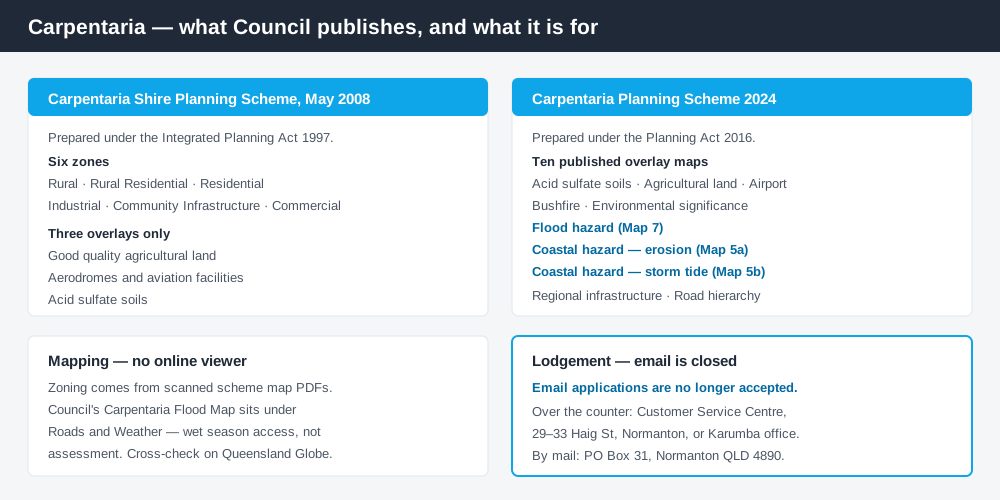
Figure 2: What Carpentaria publishes, and what each source is actually for.
Carpentaria does not run an ePlan platform or an online mapping viewer. Zoning comes from scanned map PDFs — the 2008 scheme maps, or the 2024 zone maps and the numbered overlay maps beside them. You find your lot by eye, which is slower and less certain than it sounds.
For state layers, cross-check on the Queensland Globe. Council also publishes a Carpentaria Flood Map under Roads and Weather — about road access in the wet rather than planning assessment, but it tells you a great deal about a site. How to check overlays covers the method.
What catches Carpentaria owners out
Water, from both directions. Normanton floods off the Norman River in the monsoon; Karumba sits on the coast and takes storm tide. Under the 2008 scheme no overlay code will warn you — the constraint is real whether or not a scheme layer records it, and Council, referral agencies and your insurer will all raise it. Flood hazard overlays and storm tide and coastal hazard explain how these layers behave once mapped.
Acid sulfate soils. The one hazard overlay the 2008 scheme does carry, and around Karumba and the river flats it bites — low-lying coastal soils that turn acidic when disturbed by excavation or filling. Earthworks that look trivial can trigger it. Acid sulfate soils sets out what is required.
Shipping containers. Common across the Gulf, and specifically addressed. Council allows a container on private property for up to 30 days, or 90 days alongside construction of a new dwelling. Beyond that you need building approval, with a referral to Council as a concurrence agency — and Council says it is unlikely to support one in the General residential zone. Shipping containers covers this.
Email is closed. Council's Planning Scheme page states that email applications are no longer accepted. Lodge in Normanton or by mail.
When you will probably need a DA
Work that starts a new use or intensifies an existing one, subdivides or realigns boundaries, involves earthworks, filling or clearing, or sits on constrained coastal or riverine land is likely to be assessable. Tourism accommodation, worker accommodation and fishing-related industry around Karumba are all material change of use territory. Modest work in town on an unconstrained lot is more often accepted development. Building on rural land covers the Rural zone.
What to do next
Confirm the scheme, then the zone, then read the assessment table. Fees sit in Council's Commercial and Regulatory Fees and Charges Schedule — the 2025/2026 schedule charges development applications at actual cost, with $1,200.00 charged initially for a material change of use, reconfiguring a lot, or other assessable development. Figures change annually.
If you'd rather see the zone, the mapped constraints and the likely category of assessment for a Carpentaria address in one place, an instantDA planning report does that for $169 — against the $800–$1,500 a town planner typically charges for a preliminary opinion. You can start a report in a few minutes.
Then call Council on (07) 4745 2200. Its Planning page links both schemes.
Frequently asked questions
What is Carpentaria Shire's planning scheme?
Can I email a development application to Carpentaria Shire Council?
How much does a development application cost in Carpentaria?
Does Carpentaria have flood and storm tide overlays?
Ready to generate your report?
Skip the writing. Get a council-ready planning report in 5 minutes.
Get your report