Key takeaways
- ✓The scheme is the Cassowary Coast Regional Council planning scheme, commenced 3 July 2015, currently Version 3.0 dated 17 August 2018.
- ✓It has seven zones and eleven overlay codes — a lot of overlay for a region this size.
- ✓The environmental significance overlay maps cassowary corridors and mahogany glider corridors as named layers.
- ✓Council charges a separate overlay assessment fee, and it steps up once three or more overlays apply to your site.
- ✓Council runs an ePlan site for zoning and level of assessment, plus a separate property flood mapping viewer.
Do You Need Council Approval on the Cassowary Coast?
You'll usually hear this called a development application, or DA — that's the formal name for council approval under the Planning Act 2016. On the Cassowary Coast, Council is the assessment manager, and the benchmarks it applies come from the Cassowary Coast Regional Council planning scheme.
This is a region defined by water and rainforest. Innisfail and Tully sit between the Wet Tropics World Heritage Area and the Coral Sea, on some of the wettest country in Australia, in a cyclonic wind region that took Larry in 2006 and Yasi in 2011 head on. Bananas and sugar dominate the flats; southern cassowaries move through the vegetation between them. All of that shows up in the scheme.
In this guide: how the scheme is built, the two approval tracks, how to check an address, and what catches owners out.
Get a council-ready planning report in 5 minutes — no planner, no waiting.
Get your report →The short answer
You need a development application when the Cassowary Coast planning scheme makes your work assessable for its zone and overlays. Plenty of minor work in Innisfail and Tully is accepted development. Building approval is a separate approval and usually comes from a private certifier. Overlays are what most often change the answer here.
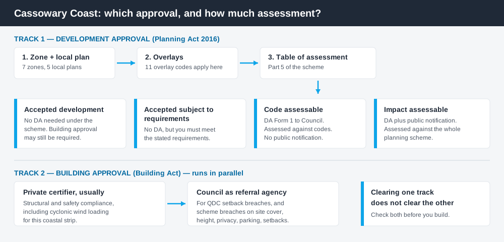
Figure 1: Two tracks run in parallel. Clearing one does not clear the other.
The Cassowary Coast planning scheme
The scheme may be cited as the Cassowary Coast Regional Council planning scheme. The commencement date was 3 July 2015, and Council's current published document is Version 3.0, dated 17 August 2018, following amendments in 2017 and 2018. Council's own pages also call it the Cassowary Coast Planning Scheme 2015 — same instrument.
It follows the standard Queensland structure — strategic framework, tables of assessment, zones, local plans, overlays, development codes — but the content is local, and Queensland schemes share that structure rather than their rules. There are seven zones: Emerging community, Environmental management and conservation, Major tourism, Rural, Rural residential, Special purpose and Township. Note what is missing. There is no low density residential zone here; town residential land sits in the Township zone, which surprises people arriving from a city scheme. What zone your property is in explains how to read that.
Five local plans sit over the top — Cardwell, Greater Mission Beach, Innisfail, Tully and Villages — each with its own code and tables of assessment. Your address may sit in a zone and a local plan at once.
Eleven overlays, and they bite
Spend 5 minutes, not 3 weeks
instantDA generates a council-ready planning report for Queensland development applications. No town planner. No waiting.
Get your report →The scheme carries eleven overlay codes: acid sulfate soils, airport environs, bushfire hazard, coastal protection, environmental significance, extractive resources, flood hazard, heritage, landslide hazard, scenic amenity, waterway corridors and wetlands.
The environmental significance overlay is what makes this council distinctive. It applies to areas of high and general environmental significance, strategic rehabilitation areas, and — named explicitly on the overlay maps — cassowary corridors and mahogany glider corridors. It also reaches land within 100 metres of a mapped area of environmental significance, so a neighbour's mapping can pull your site in. The code asks development in a corridor to maintain or enhance ecological connectivity and habitat extent, and to minimise impacts on native fauna movement. Biodiversity overlays and vegetation management cover these layers.
Flood hazard maps four tiers — low, high, extreme and potential. Coastal protection deals with erosion prone areas, vulnerable areas and storm tide hazard areas along a coast running from Kurrimine Beach through Mission Beach to Cardwell. Flood hazard overlays and storm tide and coastal hazard are the two guides most owners here need.
- ✓Which of the seven zones?
- ✓Which local plan?
- ✓Cassowary or glider corridor mapped?
- ✓Flood hazard tier?
- ✓Storm tide or erosion prone?
- ✓Accepted, or assessable?
- ✓Building approval too?
Two approval tracks, not one
Development approval is a Planning Act 2016 decision by Council as assessment manager, about land use, siting, scale and compliance with the scheme's codes.
Building approval is a Building Act decision about whether the structure complies with the building assessment provisions, usually given by a private certifier. Here that track is no formality — the coastal strip falls in cyclonic wind Region C under the Australian wind loading standard, so tie-down, roof fixing and cladding are engineered well beyond south-east norms. Council also acts as a referral agency for some building work, including Queensland Development Code setback breaches and scheme breaches on site cover, setbacks, height, privacy, car parking or outdoor living. Building approval versus development approval sets out the split.
Checking your own address
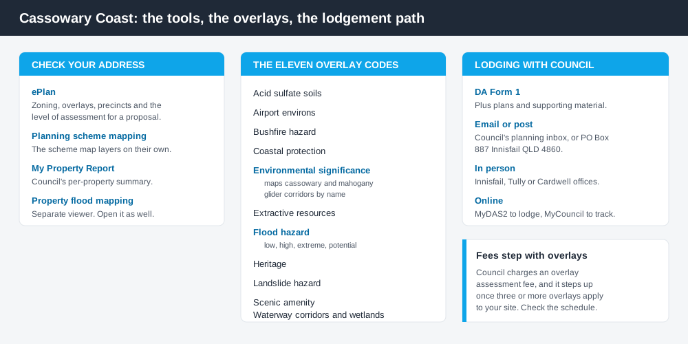
Figure 2: What Council publishes, and what each tool is actually for.
Council runs a proper ePlan site. It lets you search and print the scheme, enquire on a property for its zoning, overlays, precincts and plans, and check the level of assessment for a proposed development. That is the best starting point. Council also publishes separate planning scheme mapping, a My Property Report tool, and a dedicated property flood mapping viewer outside the scheme maps — open that too, because flood is mapped in more detail there.
Applications are lodged using DA Form 1 — by email to Council's planning inbox, by post, in person at Innisfail, Tully or Cardwell, or online through MyDAS2. Existing applications are tracked on MyCouncil. Cross-check state layers on the Queensland Globe.
What catches Cassowary Coast owners out
Overlay count changes the fee. Council's 2025/26 fees and charges list an overlay assessment fee that steps up once three or more overlays apply. With eleven overlays in the scheme, coastal and creekside sites routinely trip several at once. The base fee for a code assessable material change of use is $1,400.00 in that schedule, with overlay assessment charged on top.
Corridors are not just national park. A cassowary corridor can run through freehold cane and banana country. Owners assume the mapping stops at the World Heritage boundary. It does not.
Flood is ordinary, not exceptional. The scheme's strategic framework treats flooding and cyclones as the region's defining hazards, and says land subject to extreme hazard flooding is not suitable for urban development. Filling your way out engages the excavating and filling code. Checking overlays properly is the habit to build.
When you will probably need a DA
Work that starts a new use, intensifies an existing one, subdivides or realigns boundaries, involves earthworks or clearing, or sits in a mapped hazard or corridor area is likely to be assessable. Tourism and short-stay accommodation around Mission Beach are live categories. A dwelling house on an unconstrained Township lot is far more often accepted development.
What to do next
Pull the zone, local plan and overlays from ePlan, open the flood mapping viewer for the same address, then read the relevant table of assessment.
If you'd rather see the zone, the mapped constraints and the likely category of assessment in one place, an instantDA planning report does that for $169 — against the $800–$1,500 a town planner typically charges for a preliminary opinion. You can start a report in minutes.
Then talk to Council. A pre-lodgement discussion is optional but useful where overlays stack. Council's Development Assessment page has the process, forms and current fees.
Frequently asked questions
What is the Cassowary Coast planning scheme?
Does Council have online planning maps?
Do cassowaries actually affect development approval?
How much is a development application here?
How do I lodge a development application?
Ready to generate your report?
Skip the writing. Get a council-ready planning report in 5 minutes.
Get your report