Key takeaways
- ✓The scheme is the Charters Towers Regional Town Plan Version 2.0, adopted 29 January 2020 and commenced 10 February 2020.
- ✓There are six overlays, and two of them are about built form: the Heritage overlay and the Residential character overlay.
- ✓The Heritage overlay is mapped on overlay map OM4 and picks up local heritage places, heavily concentrated along Mosman and Gill Streets.
- ✓The Residential character overlay controls how dwelling houses and dual occupancies look in mapped streetscapes and gateways.
- ✓All building work in the region is certified privately — Council is a referral agency for some of it, not the certifier.
Do You Need Council Approval in Charters Towers?
You'll usually hear this called a development application, or DA — that's the formal name for council approval under the Planning Act 2016. In Charters Towers, Council is the assessment manager, and the benchmarks it applies come from the Charters Towers Regional Town Plan Version 2.0.
What makes this council different is written into its streets. Charters Towers grew out of the gold rush of the late nineteenth century, was known at the time as "The World", and kept the buildings to prove it. Council's own strategic framework points at the heritage buildings "particularly along Mosman and Gill Street", the monuments and the features on Towers Hill. Two of the scheme's six overlays exist to protect that built form.
In this guide: how the Town Plan works, the two approval tracks, how to check an address, and what catches owners out.
Get a council-ready planning report in 5 minutes — no planner, no waiting.
Get your report →The short answer
You need a development application in Charters Towers whenever the Town Plan makes your proposal assessable for your zone or an overlay that affects your land. Heritage and residential character mapping in town changes the answer for work that would be routine elsewhere. Building approval is a separate approval through a private certifier.
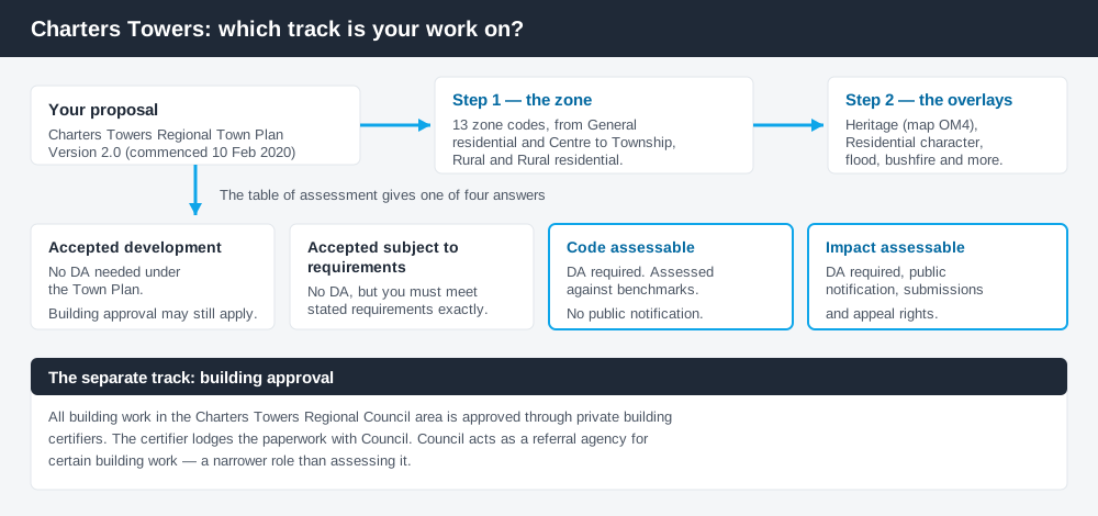
Figure 1: Two tracks run in parallel. Clearing one does not clear the other.
The Charters Towers Regional Town Plan
On 29 January 2020 Council resolved to adopt the Charters Towers Regional Town Plan Version 2.0, and it commenced on 10 February 2020. It covers the whole region — the urban area plus Ravenswood, Pentland, Greenvale, Homestead, Mingela and the smaller localities.
The Town Plan follows the standard Queensland structure — strategic framework, zones, tables of assessment, overlays, codes — with council-specific content layered in. Queensland schemes share that structure, not their contents, so a zone name you know from another region will not behave the same way here.
Thirteen zone codes do the work, from General residential, Centre and Industry through to Township, Rural and Rural residential. Most of the region is Rural. What zone your property is in explains how to read that.
The overlays that actually bite
Spend 5 minutes, not 3 weeks
instantDA generates a council-ready planning report for Queensland development applications. No town planner. No waiting.
Get your report →There are six: Bushfire hazard, Flood hazard, Heritage, Natural environment, Regional infrastructure, and Residential character. Two of them are about built form, and those are the ones outsiders miss.
The Heritage overlay is mapped on overlay map OM4 and identifies local heritage places. The scheme's outcome is that their cultural heritage values are conserved and protected from inappropriate development, and that development is compatible with the cultural heritage significance of the place.
The Residential character overlay is a different tool. Council describes it as identifying important streetscapes and gateways, so that the appearance of dwelling houses and dual occupancies complements local cultural heritage places and enhances the streetscape character of neighbourhoods within the urban area. It is about how ordinary houses look in mapped streets — not about listing them.
Both are worth reading properly: heritage overlays and character overlays cover how each behaves, and how to check overlays covers finding them for a specific lot.
Two approval tracks, not one
Development approval is the Planning Act 2016 decision. Council is the assessment manager and assesses land use, siting, scale and compliance with the Town Plan's codes.
Building approval is a Building Act decision about whether the structure itself complies. Charters Towers is unambiguous here: all building work in the region is approved through private building certifiers, and the certifier lodges the paperwork with Council. Council does act as a referral agency for certain building work — a narrower role than assessing it. Building approval versus development approval sets out the split.
- ✓Which zone?
- ✓Heritage overlay — is the place on OM4?
- ✓Residential character overlay?
- ✓Flood or bushfire hazard?
- ✓Accepted, or assessable?
- ✓Private certifier engaged?
Checking your own address
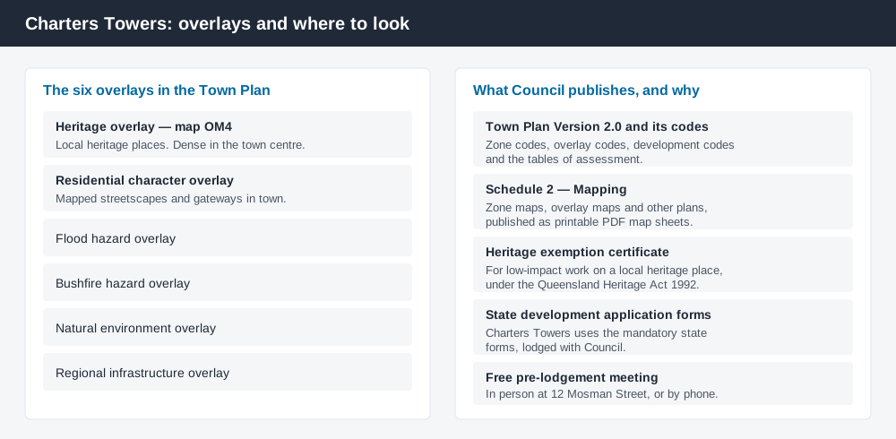
Figure 2: What Council publishes, and what each source is actually for.
Council publishes the Town Plan's zone, overlay and other plans mapping as Schedule 2 of the scheme, online as printable PDFs on its Mapping page. Start there for the zone, then check the same address against overlay map OM4 and the residential character mapping. For state layers — vegetation, mining tenements, environmental values — cross-check on the Queensland Globe.
Charters Towers does not lodge through a third-party platform. Applicants use the mandatory state government development application forms, and Council offers a complimentary pre-lodgement service, in person at the Administration Centre at 12 Mosman Street or by phone.
What catches Charters Towers owners out
Heritage exemption certificates. If you own a local heritage place, some repair work can proceed under a heritage exemption certificate issued under the Queensland Heritage Act 1992 — Council gives examples such as replacing a roof, reopening verandahs that were enclosed in the wrong materials, removing later additions, and small sheds or carports that do not affect views of the place from the street. If your work does not qualify, you lodge a DA instead. Assuming the exemption without asking is where owners come unstuck.
Demolition and removal. Old timber buildings get moved and pulled down in North Queensland all the time. On a mapped heritage place, or in a mapped character streetscape, that is not a decision to make on the day the truck arrives. Demolition approval covers it.
Rural scale. Outside town the region is grazing country, the Burdekin River and its tributaries, and active gold mining around Ravenswood. Large holdings do not mean unregulated: reconfiguring a lot, extractive industry and operational work all engage the scheme. Building on rural land covers that.
When you will probably need a DA
Work that starts a new use or intensifies an existing one, subdivides or realigns boundaries, involves earthworks or clearing, alters the external appearance of a place on the Heritage overlay, or changes how a dwelling presents to a mapped character streetscape is likely to be assessable. Modest work behind the building line, on an unconstrained lot outside both built-form overlays, is far more often accepted development.
What to do next
Get the zone from Council's mapping, check the same address against the heritage and character overlays, then read the table of assessment for what you intend to do.
If you'd rather see the zone, the mapped overlays and the likely category of assessment for a Charters Towers address in one place, an instantDA planning report does that for $169 — against the $800–$1,500 a town planner typically charges for a preliminary opinion. You can start a report in a few minutes.
Then book the free pre-lodgement meeting. Council's Planning Scheme page has the Town Plan, the codes and the maps.
Frequently asked questions
What is Charters Towers' planning scheme called?
Does Charters Towers have a heritage overlay?
Who issues building approval in Charters Towers?
Do I need approval to repair a heritage building in Charters Towers?
How much does a development application cost in Charters Towers?
Ready to generate your report?
Skip the writing. Get a council-ready planning report in 5 minutes.
Get your report