Key takeaways
- ✓Gympie runs on the Gympie Regional Council Planning Scheme 2013, currently Version 4.0, which took effect on 1 October 2024.
- ✓The scheme has no separate overlay codes — overlay provisions sit inside each zone code, which trips up people used to other councils.
- ✓Flood Hazard is the overlay that bites hardest, in a town whose February 2022 flood was its highest since 1893.
- ✓A temporary local planning instrument for biodiversity values commenced on 23 February 2026 and runs to February 2028.
- ✓Council is preparing a replacement planning scheme, so check the current version before relying on any saved document.
Do You Need Council Approval in Gympie?
You'll usually hear this called a development application, or DA — that's the formal name for council approval under the Planning Act 2016. In the Gympie region, Gympie Regional Council is the assessment manager for most of them, and the rules it applies come from the Gympie Regional Council Planning Scheme 2013.
What makes Gympie unusual is not the scheme's age but its drafting: it has no separate overlay codes at all. The provisions dealing with flood, bushfire, heritage and agricultural land live inside each zone code.
Get a council-ready planning report in 5 minutes — no planner, no waiting.
Get your report →The short answer
In Gympie, you need a development application when the planning scheme's tables of assessment make your work code assessable or impact assessable for your zone and any overlay. Much minor domestic work is accepted development. Building approval is separate and usually comes from a private certifier.
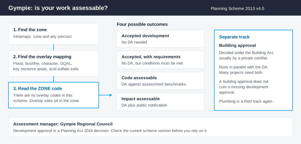
Figure 1: Two parallel tracks. Clearing one does not clear the other.
The Gympie Regional Council Planning Scheme 2013
The scheme was adopted in June 2013 and commenced on 1 July 2013. Council adopted Amendment Package 3 in August 2024; it was gazetted on 27 September 2024 and took effect on 1 October 2024, creating Version 4.0, the current version.
Council is also preparing an entirely new planning scheme, intended to cover the next 20 to 25 years. It has not commenced. Until it does, Version 4.0 governs, and a PDF you downloaded a few years ago may well be a superseded version.
Like every Queensland scheme, Gympie's follows the standard state structure — strategic framework, zone codes, tables of assessment — but Queensland schemes are far less uniform than that structure suggests, and Gympie's zone naming shows it. You will find a Residential Living zone, a Residential Choice zone, a Character Residential zone, a Tourist Accommodation zone, a Township zone and a Limited Development (Constrained Land) zone. How to find out what zone your property is in covers reading that structure generally.
Two approval tracks, not one
Spend 5 minutes, not 3 weeks
instantDA generates a council-ready planning report for Queensland development applications. No town planner. No waiting.
Get your report →Development approval is a Planning Act 2016 decision. Council is the assessment manager. It deals with land use, siting, scale and compliance with the assessment benchmarks in the scheme.
Building approval is a Building Act decision about whether the structure complies with the building assessment provisions. It is usually given by a private certifier, not by Council.
Council sets out the categories plainly: if a development application is not required, the development is accepted development, and that can still be subject to meeting certain requirements. Where approval is required, it will be either code assessment against the benchmarks in the scheme, or impact assessment, which requires public notification and can attract third-party appeal rights.
Holding a building approval does not cure the absence of a development approval where one was needed. Building approval versus development approval covers the distinction in full.
- ✓What is the zone and precinct?
- ✓Which overlay maps touch the land?
- ✓Is the work accepted development?
- ✓If accepted, is it accepted subject to requirements?
- ✓Do you also need building approval?
- ✓Does the biodiversity instrument apply?
Checking your own address
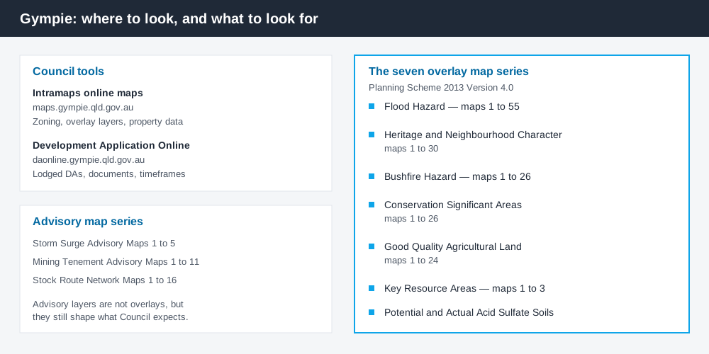
Figure 2: Council's tools and the seven overlay map series.
Council runs an online maps portal, branded Intramaps, at maps.gympie.qld.gov.au, covering zoning, property data and the planning scheme mapping layers. That is where you establish the zone and identify which overlay map series touch the land.
Separately, Council operates Development Application Online, its own DA tracker, at daonline.gympie.qld.gov.au, showing applications lodged over a property, the documents filed and the timeframes. Gympie does not use Development.i. What has actually been approved nearby is usually more instructive than the code text.
What catches Gympie owners out
Flood. The scheme carries Flood Hazard Overlay Maps 1 to 55 — by far its largest map series, and a fair measure of how much of the region is affected. Gympie is among the most flood-exposed towns in Queensland; the Mary River peaked at 22.96 metres at the Gympie gauge on 27 February 2022, the highest since the 25.45 metre flood of 1893. Floor levels, siting and sometimes the category of assessment all follow from that mapping. The flood hazard overlay explained covers how these provisions work.
Heritage and character. Mary Street's gold-rush streetscape and the older residential areas around it are picked up by Heritage and Neighbourhood Character overlay mapping and, in places, the Character Residential zone. Demolition and street-facing work are where applications get difficult. The Character residential zone explained covers the zone.
The coast. Rainbow Beach and Tin Can Bay sit outside the flood story entirely and pick up different constraints, including Storm Surge advisory mapping and Potential and Actual Acid Sulfate Soils overlay mapping. Storm tide and coastal hazard and acid sulfate soils both apply out there far more often than in town.
The hinterland. Good Quality Agricultural Land, Key Resource Areas, Bushfire Hazard and Conservation Significant Areas mapping all run across the rural balance of the region. A temporary local planning instrument protecting biodiversity values also commenced on 23 February 2026 and runs to 23 February 2028 unless repealed earlier; the state required the Rural zone to be excluded from parts of it, so where you sit changes what applies. Building on rural land covers the rural picture.
When you will probably need a DA
Work that changes the use of a property, adds a dwelling, subdivides, involves demolition in a character area, or sits within flood, bushfire or coastal mapping is likely to be assessable. Minor domestic work on an unconstrained lot is much more often accepted development, subject to any requirements attached to that acceptance.
Fees are set annually. For 2026-27 the application fee for a material change of use for a dwelling house, dwelling unit, caretaker's accommodation or community residence is listed at $975.00, with multipliers applied for impact assessment and hard-copy lodgement. Confirm the current figure for your own use class.
What to do next
Establish the zone on Intramaps, list every overlay map series touching the land, then read the relevant section of the zone code — not a separate overlay code, because there isn't one.
If you'd rather see the zone, the overlays and the likely category of assessment for a Gympie address pulled together in one place, an instantDA planning report does that for $169 — against the $800–$1,500 a town planner typically charges for a preliminary opinion. You can start a report in a few minutes.
Then confirm with Council's planning team before you engage a designer. For anything touching flood, character or the coast, that conversation is worth having early.
Frequently asked questions
What is Gympie's planning scheme?
Where do I check zoning for a Gympie property?
Does Gympie use Development.i?
Why can't I find the flood overlay code?
Is building approval the same as council approval in Gympie?
Ready to generate your report?
Skip the writing. Get a council-ready planning report in 5 minutes.
Get your report