Key takeaways
- ✓The scheme is the Isaac Regional Planning Scheme 2021, adopted 24 February 2021, in effect from 1 April 2021, now at Version 1.1 effective 1 July 2024.
- ✓Workforce accommodation is not listed in the tables of assessment for any zone, so a new proposal falls to impact assessment and must demonstrate need.
- ✓Overlay Map OM10 maps potentially hazardous dust levels around Moranbah — a dwelling house in the Rural zone that would normally be accepted becomes impact assessable inside it.
- ✓The Moranbah Priority Development Area was revoked from 14 February 2025, so that land now sits under the planning scheme.
- ✓Coastal hazard mapping applies at Clairview, Carmila Beach, Greenhill and St Lawrence; Clermont carries the region's worst flood history.
Do You Need Council Approval in Isaac Regional Council?
You'll usually hear this called a development application, or DA — that's the formal name for council approval under the Planning Act 2016. In Isaac, Council is the assessment manager, and the rules it applies come from the Isaac Regional Planning Scheme 2021.
Isaac is the Bowen Basin coal heartland. Moranbah, Dysart, Middlemount, Glenden, Clermont and Nebo sit alongside some of the country's largest coal operations, and the region runs east to a quiet coast at Carmila, Clairview, Greenhill and St Lawrence. That gives the scheme concerns you will not find in a city scheme: non-resident workforce accommodation, mine dust, and land regulated by somebody other than Council.
Get a council-ready planning report in 5 minutes — no planner, no waiting.
Get your report →The short answer
Yes, whenever the Isaac Regional Planning Scheme 2021 makes your work assessable for its zone or an overlay. Modest work on an unconstrained town lot is often accepted development. Workforce accommodation and anything inside the Moranbah dust overlay are the big exceptions — both push you into impact assessment.
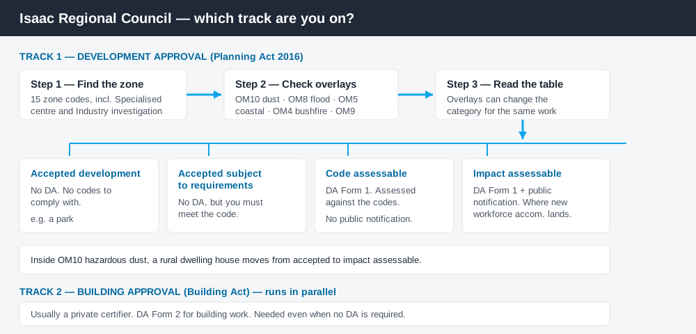
Figure 1: Two tracks run in parallel. Answering one does not answer the other.
The Isaac Regional Planning Scheme 2021
Council adopted the scheme on 24 February 2021 and it came into effect on 1 April 2021. The current consolidation is Version 1.1, effective 1 July 2024, which brought in new coastal hazard mapping and a strategic framework map of workforce accommodation locations.
It follows the standardised structure used across Queensland — strategic framework, zones, overlays, codes, tables of assessment — but Queensland schemes share a structure, not their content. There are fifteen zone codes, including a Specialised centre zone that exists purely to acknowledge existing workforce accommodation inside urban centres. Working out what zone your property is in is the first step in reading any of it.
The scheme does not cover everything inside the local government area. The Galilee Basin Development Scheme operates separately, and development on mining tenements authorised under the Mineral Resources Act 1989 sits largely outside the Planning Act. Neighbouring parcels can run on different rulebooks.
Two approval tracks, not one
Spend 5 minutes, not 3 weeks
instantDA generates a council-ready planning report for Queensland development applications. No town planner. No waiting.
Get your report →Development approval is a Planning Act 2016 decision about land use, siting, scale and compliance with the scheme's codes. Council is the assessment manager, and its guidance splits work into accepted development, accepted subject to requirements, code assessable and impact assessable — plus prohibited development you cannot apply for.
Building approval is a Building Act decision about whether the structure complies with the building assessment provisions, usually given by a private certifier. A shed can be accepted development under the scheme and still need a building approval. Building approval versus development approval covers the split; accepted versus assessable covers the categories.
DA Form 1 is used for code and impact assessable applications, DA Form 2 for building work. Both are State forms, downloaded and then lodged with Council — Isaac does not run a self-service online lodgement portal.
Checking your own address
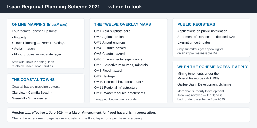
Figure 2: What Isaac publishes, and what each source is actually for.
Council runs an IntraMaps online mapping system with four themes — Property, Town Planning, Aerial Imagery and Flood Studies. Town Planning gives you the zone and the mapped overlays; Flood Studies is separate, and worth opening on its own because Council's flood study program is still expanding and a Major Amendment (Flood Hazard) is in preparation.
The scheme's twelve overlay maps are also published individually as PDFs. Two of them — agriculture land and potential hazardous dust — have no overlay code. They are mapped and they change categories of assessment, but there is no code to comply with.
- ✓Which of the fifteen zones?
- ✓Inside OM10 hazardous dust?
- ✓Flood hazard overlay OM8?
- ✓Coastal hazard overlay OM5?
- ✓Mining tenement or Galilee Basin scheme land?
- ✓Building approval too?
What catches Isaac owners out
Workforce accommodation. This is the defining planning issue in the region, and the scheme handles it bluntly. It is not listed in the tables of assessment for any zone — so a new proposal falls into "any other use not listed", which is impact assessment. Council estimates up to 30,000 beds already constructed or approved, and says any new proposal must demonstrate need against that supply. Relocatable modular buildings that do not meet contemporary urban design standards are not to be located in established communities at all.
Mine dust. Overlay Map OM10 shows areas around Moranbah subject to potentially hazardous dust levels. In the Rural zone a dwelling house, dual occupancy, dwelling unit or rural workers' accommodation is normally accepted subject to requirements — but inside OM10 it becomes impact assessable, and a site-based dust assessment settles it. Building on rural land covers the wider picture.
Flood. Clermont's 1916 flood washed away the town's central business district and, on Council's own account, claimed at least 65 lives. Under the current scheme, a material change of use for a sensitive land use, low impact industry, nature based tourism, service industry or warehouse inside the flood hazard overlay becomes code assessable. Flood hazard overlays explains the layer.
The coast. Coastal hazard overlay mapping applies at Clairview, Carmila Beach, Greenhill and St Lawrence, dealing with erosion prone areas, storm tide inundation and a coastal planning level. Even a new dwelling house there carries requirements. Coastal hazard overlays is the companion read.
Moranbah's changed status. The Moranbah Priority Development Area was revoked on 13 February 2025. From 14 February 2025, new applications over that land are assessed under the Planning Act 2016 framework — which for most sites means this scheme.
When you will probably need a DA
Anything that starts a new use, materially increases the intensity of an existing one, subdivides or realigns boundaries, or moves earth at scale is likely assessable. So is a use that would otherwise be accepted, once an overlay catches it. Material change of use sets out what counts.
What to do next
Pull the zone from Council's Town Planning mapping theme, check the same address against OM8 flood, OM10 dust and OM5 coastal hazard, then read the table of assessment for what you intend to do.
If you'd rather have the zone, the mapped constraints and the likely category of assessment for an Isaac address in one document, an instantDA planning report does that for $169 — against the $800–$1,500 a town planner typically charges for a preliminary opinion. You can start a report in a few minutes.
Then talk to Council before you spend money on drawings. Council's Planning Scheme page holds the scheme and every overlay map, and the online mapping page is where you check your lot. Fees are set annually in Council's adopted schedule, so confirm the current figure directly.
Frequently asked questions
What is Isaac Regional Council's planning scheme?
Do I need approval for workforce accommodation in Isaac?
Does Isaac Regional Council have online planning maps?
What is the Moranbah dust overlay?
How much does a development application cost in Isaac?
Ready to generate your report?
Skip the writing. Get a council-ready planning report in 5 minutes.
Get your report