Key takeaways
- ✓Redland City Council's planning scheme is the Redland City Plan 2018, currently version 14, in effect from 10 November 2025.
- ✓Red-e-map is Council's mapping tool for zones and overlays; Development.i is where you look up applications.
- ✓Development approval and building approval are separate decisions, and on the bay islands a third wastewater track applies.
- ✓Coastal erosion, storm tide and state koala mapping are the constraints that most often change the answer in Redlands.
- ✓Toondah Harbour and Weinam Creek are Priority Development Areas outside the City Plan entirely.
Do You Need Council Approval in Redland City?
You'll usually hear this called a development application, or DA — that's the formal name for council approval under the Planning Act 2016. In Redland City, Council is the assessment manager for most of them, and the rules it applies come from the Redland City Plan 2018.
What makes Redlands unusual is geography. This is one of the few Queensland councils split between a mainland and a group of inhabited bay islands, and the planning treatment genuinely differs between them. Add coastal erosion and storm tide mapping along most of the shoreline, state koala mapping across the mainland, and two Priority Development Areas sitting outside the City Plan, and the answer moves around far more than in a landlocked council.
Get a council-ready planning report in 5 minutes — no planner, no waiting.
Get your report →The short answer
In Redland City you need a development application when the Redland City Plan 2018 makes your work assessable for its zone and overlays. Much minor domestic work is accepted development. Building approval is separate and usually sits with a private certifier. On the bay islands, extra referrals and wastewater rules apply.
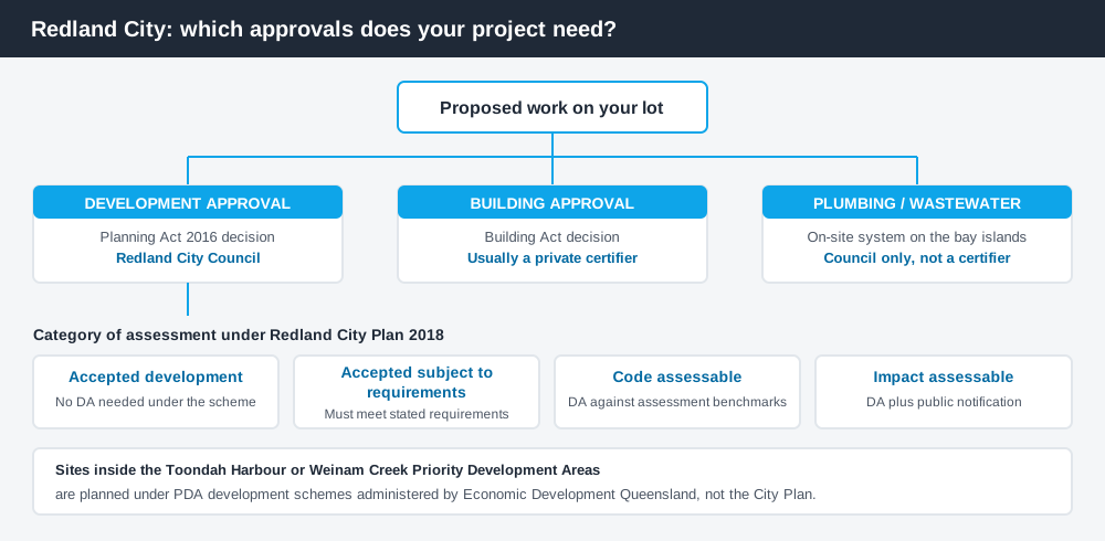
Figure 1: Three tracks can run at once. Answering one does not answer the others.
Redland City Plan 2018
The scheme is the Redland City Plan 2018, which commenced on 8 October 2018. The current version 14 was adopted on 17 September 2025 and took effect on 10 November 2025. Council is also preparing a new Redlands Coast City Plan, so the current scheme is kept alive by amendment while that work runs.
Like every Queensland scheme, the City Plan follows the Queensland Planning Provisions structure — a strategic framework, zone codes, overlay codes and tables of assessment — but the codes themselves are Redland's own. How to find what zone your property is in covers reading that structure. Zoning is mapped on separate sheets for the mainland, for North Stradbroke Island (Minjerribah) and for the Southern Moreton Bay Islands, reflecting how differently those places are planned.
Three approval tracks, not one
Spend 5 minutes, not 3 weeks
instantDA generates a council-ready planning report for Queensland development applications. No town planner. No waiting.
Get your report →Development approval is a Planning Act 2016 decision. Council is the assessment manager, and it deals with use, siting, scale and compliance with the codes in the City Plan.
Building approval is a Building Act decision about whether the structure complies with the building assessment provisions, and it is usually given by a private certifier rather than Council. Building approval versus development approval sets out the distinction.
Plumbing and wastewater is the third track, and in Redlands it is not a footnote. There is no reticulated wastewater on the Southern Moreton Bay Islands — Karragarra, Macleay, Perulpa, Lamb and Russell — so every property needs its own on-site effluent treatment and disposal system. Council requires a site and soil evaluation and a soil permeability test before a new house, and the disposal area can limit your building footprint and even the number of bedrooms. Island plumbing approval comes only from Council.
- ✓What zone applies?
- ✓Which overlays touch the lot?
- ✓Accepted, accepted subject to requirements, code assessable or impact assessable?
- ✓Building approval as well?
- ✓Any wastewater or soil constraint?
- ✓Does a concurrence agency referral apply?
Checking your own address
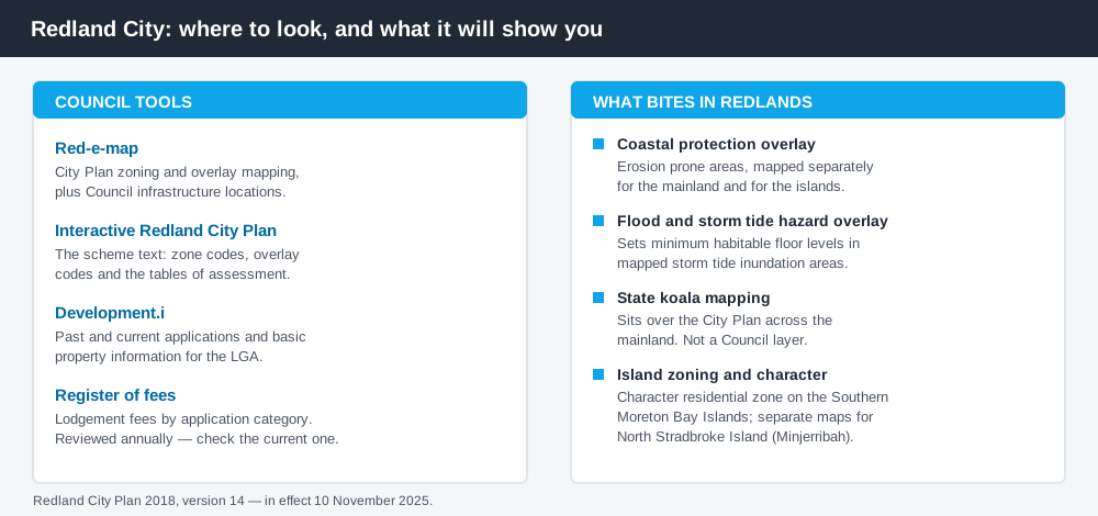
Figure 2: Council tools left, the constraints they reveal right.
Council's mapping tool is Red-e-map, which shows City Plan zoning and overlay information along with Council infrastructure. An Interactive Redland City Plan reads the scheme text against those maps.
For applications, Council uses Development.i, holding past and current application details for the local government area. Approved applications on comparable nearby lots show what Council actually accepts and conditions. Using Development.i covers that.
Red-e-map will not show you everything. State koala mapping and other state layers sit over the City Plan and are published separately. How to check overlays walks through both.
What catches Redlands owners out
Coastal erosion and storm tide. Redlands has a Coastal protection (erosion prone areas) overlay and a Flood and storm tide hazard overlay, each mapped on separate mainland and islands sheets. The storm tide overlay drives minimum habitable floor levels, and the erosion overlay can make otherwise ordinary work assessable on its own. That is not theoretical: Council's fee register carries a specific application category for work on a dwelling house where the only trigger is the erosion prone areas overlay. The coastal hazard overlay explained and storm tide and coastal development cover how these are assessed.
Koalas. Redlands is one of the most significant koala areas in South East Queensland, and the mainland sits within state koala mapping administered under the Planning Regulation 2017 rather than by the City Plan. Where mapped habitat is involved, clearing can be prohibited or assessable at state level regardless of your zone. Koala habitat and development explains the framework.
Island character. On the Southern Moreton Bay Islands the dominant residential zoning is the Character residential zone, written specifically for island living areas of dwelling houses. It is not the same thing as a pre-war character overlay. The Character residential zone covers how these zones work.
Priority Development Areas. Toondah Harbour at Cleveland and Weinam Creek at Redland Bay are declared Priority Development Areas under the Economic Development Act 2012, planned through development schemes administered by Economic Development Queensland rather than the City Plan. If your site is inside one, the City Plan is not the instrument that applies.
When you will probably need a DA
Work that changes the use of a property, adds a dwelling, subdivides, clears vegetation, sits in a coastal erosion or storm tide mapped area, or exceeds the thresholds in the applicable code is likely to be assessable. A modest shed or fence on an unconstrained mainland lot is much more often accepted development, subject to any requirements attached to that acceptance.
Fees follow the category. In the 2026-2027 register of fees, Council sets a lodgement fee of $825.00 for a code assessable application for a dwelling house, dual occupancy or community residence where the only trigger is the Coastal protection (erosion prone areas) overlay. Fees are reviewed annually, so take the current figure from the register itself.
What to do next
Check the address on Red-e-map, list every overlay, then read the table of assessment for what you intend to do. If the site is on the islands, get the wastewater question answered early, because it shapes the design.
If you'd rather see the zone, the overlays and the likely category of assessment for a Redlands address pulled together in one place, an instantDA planning report does that for $169 — against the $800–$1,500 a town planner typically charges for a preliminary opinion. You can start a report in a few minutes.
Then confirm with Council before you engage a designer. For anything touching coastal hazard, koala mapping or an island lot, have that conversation first.
Frequently asked questions
What is Redland City Council's planning scheme?
How do I check the zoning of a Redlands property?
Do the Southern Moreton Bay Islands have different rules?
Is Toondah Harbour assessed by Redland City Council?
Does koala mapping stop me building in Redlands?
Ready to generate your report?
Skip the writing. Get a council-ready planning report in 5 minutes.
Get your report