Key takeaways
- ✓The scheme is the Toowoomba Regional Planning Scheme, version 28, which took effect on 28 November 2022.
- ✓Twelve overlays apply across the region, including Landslide Hazard, Flood Hazard, Neighbourhood Character and Airport Environs.
- ✓Council's smart maps show your zone, local plan and overlays; Development.i shows applications near you.
- ✓Development approval and building approval are separate. One does not substitute for the other.
- ✓Infrastructure charges differ sharply between the Urban, Township and Rural charge areas.
Do You Need Council Approval in Toowoomba?
You'll usually hear this called a development application, or DA — that's the formal name for council approval under the Planning Act 2016. In the Toowoomba Region, Council is the assessment manager for most of them, and the rules it applies come from the Toowoomba Regional Planning Scheme.
What makes this council unusual is its geographic range. One scheme covers a regional city on an escarpment, the steep land falling away down the Range, and a large rural hinterland running out through Pittsworth, Millmerran, Clifton and Crows Nest.
Get a council-ready planning report in 5 minutes — no planner, no waiting.
Get your report →The short answer
You need a development application when the Toowoomba Regional Planning Scheme makes your work assessable for your zone, local plan and overlays. Much minor domestic work is accepted development. Building approval is a separate Building Act decision, usually made by a private certifier rather than by Council.
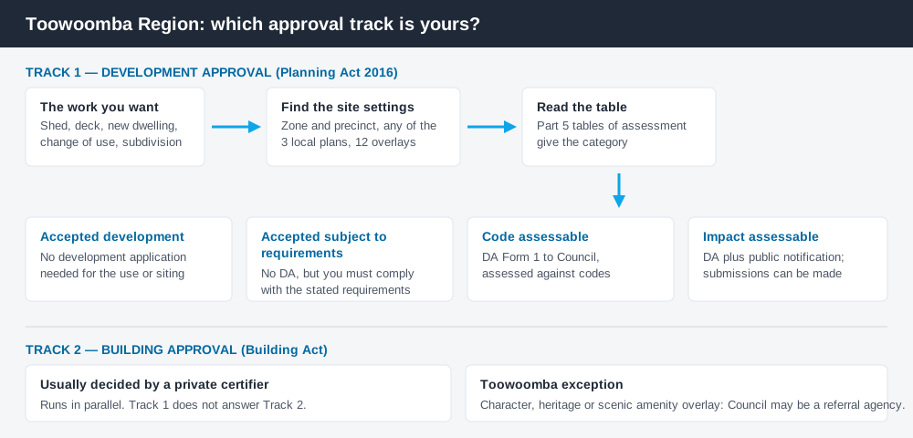
Figure 1: Two tracks run in parallel. Answering one does not answer the other.
The Toowoomba Regional Planning Scheme
The current scheme is version 28, which Council states took effect on 28 November 2022. Older documents inside it still call it the Toowoomba Regional Planning Scheme 2012 — the same instrument, amended repeatedly rather than replaced.
Like every Queensland scheme it follows the standard state structure — strategic framework, zone codes, overlay codes and tables of assessment — with Council's own codes layered on top. The structure is common; the content is not.
Zone naming is familiar but locally elaborated: a Township Zone with a Flood Management Precinct, a Rural Zone split into 100ha and 200ha precincts, a Rural Residential Zone with 4,000m², 1ha and 2ha precincts, and a Limited Development Zone for constrained land. Three local plans — Highfields, Meringandan and Meringandan West; Glenvale; and the Charlton Wellcamp Enterprise Area — sit over the zone in defined areas. How to find out what zone your property is in covers reading zone and precinct together.
Two approval tracks, not one
Spend 5 minutes, not 3 weeks
instantDA generates a council-ready planning report for Queensland development applications. No town planner. No waiting.
Get your report →Development approval is a Planning Act 2016 decision. Council is the assessment manager, and it deals with land use, siting, scale and compliance with the codes in the scheme.
Building approval is a Building Act decision about whether the structure meets the building assessment provisions. It is usually given by a private certifier, not by Council.
Separate approvals, separate legislation, separate decision-makers. A carport can be accepted development under the scheme and still need building approval; holding a building approval does not cure a missing development approval. Building approval versus development approval covers this properly.
There is a Toowoomba wrinkle. Where building work sits in the Neighbourhood Character, Heritage or Scenic Amenity overlay, Council can be pulled into a building application as a referral agency assessing amenity and aesthetic impact — so even a class 10 structure can end up in front of a Council planner.
- ✓What zone and precinct applies?
- ✓Is a local plan over the site?
- ✓Which overlays apply?
- ✓Is the work accepted, code assessable or impact assessable?
- ✓Do you also need building approval?
Checking your own address
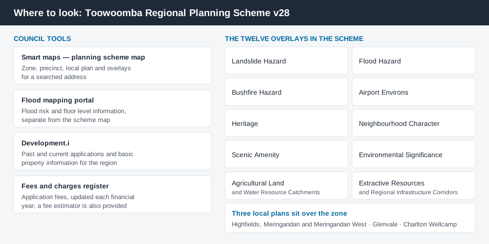
Figure 2: Different Council tools answer different questions.
Council publishes its planning layers through online mapping — smart maps, where the planning scheme map lets you search an address and see the zone, any local plan and the overlays affecting it. A separate flood portal carries flood risk and floor level information.
Council also runs Development.i, its online planning and development system, giving public access to past and current application details and basic property information. What has been approved on comparable sites nearby tells you what Council accepts and what conditions it attaches. Lodging and tracking through Development.i explains that system.
For state layers the scheme does not carry, cross-check the site on the Queensland Globe.
What catches Toowoomba owners out
Steep land. The Landslide Hazard Overlay bites hardest along the escarpment and the slopes below the Range. Where it applies, geotechnical input is needed early, and it changes what is buildable rather than how it looks.
Flood. The Flood Hazard Overlay maps flood risk areas FR1 to FR4, balance and flood island areas, and two overland flow path categories. The 2011 event through East Creek and West Creek is why the mapping is this detailed, and Council declares a freeboard above 300mm in the designated flood hazard area. How the flood hazard overlay works covers the framework.
Character and heritage. The Neighbourhood Character and Heritage overlays cover much of Toowoomba's older housing stock, and Council keeps a register of heritage and neighbourhood character places. Demolition and street-facing work are where these get difficult. The character overlay explained is a good start.
Rural assumptions. Owners of hinterland blocks often assume the country is unregulated. The Agricultural Land, Water Resource Catchments, Extractive Resources and Bushfire Hazard overlays all reach well into the rural zones. Building on rural land sets out what still needs approval.
Airport and freight. The Airport Environs Overlay, the Toowoomba Airport Precinct, and the Charlton Wellcamp Enterprise Area local plan shape development on the region's western side.
When you will probably need a DA
Work that changes the use of a property, adds a dwelling, reconfigures a lot, sits on steep or flood-affected land, or touches a character, heritage or airport overlay is likely to be assessable. Modest domestic work on an unconstrained suburban lot is much more often accepted development.
Budget for more than the application fee. Toowoomba adopts infrastructure charges under its Charges Resolution — Charges Resolution No. 7, adopted 19 August 2025, is the current one — and the amount depends on the charge area and the number of bedrooms, so an identical dwelling can be charged very differently in an urban versus a rural charge area. Council caps its charges at the State's prescribed maximums. Take the current figures from Council's infrastructure charges page and application fees from the fees and charges register — both change annually. Infrastructure charges in Queensland explains the calculation.
What to do next
Find your zone, any local plan and every overlay on Council's smart maps, then read the table of assessment for what you intend to build.
If you'd rather see the zone, the overlays and the likely category of assessment for a Toowoomba address in one place, an instantDA planning report does that for $169 — against the $800–$1,500 a town planner typically charges for a preliminary opinion. You can start a report in a few minutes.
Then confirm with Council's technical advice team before you commission drawings. On escarpment land, in a flood risk area, or in the character overlay, have that conversation early.
Frequently asked questions
What is Toowoomba's planning scheme?
How do I check the zoning of a Toowoomba property?
Do I need council approval for a shed or carport in Toowoomba?
What overlays apply in the Toowoomba Region?
Are infrastructure charges different in rural parts of the region?
Ready to generate your report?
Skip the writing. Get a council-ready planning report in 5 minutes.
Get your report