Key takeaways
- ✓Etheridge runs on the Etheridge Shire Planning Scheme, adopted Version 1.1, with a commencement date of 1 December 2025.
- ✓There are only two zones — Rural, and Township with Commercial, Industrial, Residential and Rural Residential precincts.
- ✓The scheme has no overlay codes. Flood comes from maps FH-1 to FH-5 in Schedule 2; bushfire comes from state mapping.
- ✓Being on a local heritage place in Schedule 3 removes the accepted development pathway almost everywhere.
- ✓Anything not listed in the table of assessment for your zone falls to impact assessment by default.
Do You Need Council Approval in Etheridge Shire?
You'll usually hear this called a development application, or DA — that's the formal name for council approval under the Planning Act 2016. In Etheridge, Council is the assessment manager, and the rules it applies come from a scheme that is brand new: the Etheridge Shire Planning Scheme, adopted Version 1.1.
Etheridge is a Gulf Savannah shire of roughly 40,000 square kilometres — large rural holdings served by Georgetown and Mount Surprise, plus Forsayth and Einasleigh, and 799 residents at the 2016 census. Cattle, mining and tourism carry the economy: the Savannah Way runs through, and the scheme names Cobbold Gorge, Copperfield Gorge, Undara Volcanic National Park and fossicking sites among the drawcards.
In this guide: how the new scheme works, the two approval tracks, how to check an address, and what catches owners out.
Get a council-ready planning report in 5 minutes — no planner, no waiting.
Get your report →The short answer
In Etheridge Shire you need a development application when the Etheridge Shire Planning Scheme makes your work assessable in your zone. The scheme is small, so a lot falls straight to impact assessment. Building approval is separate, and Council does not run an online lodgement portal — you contact the office.
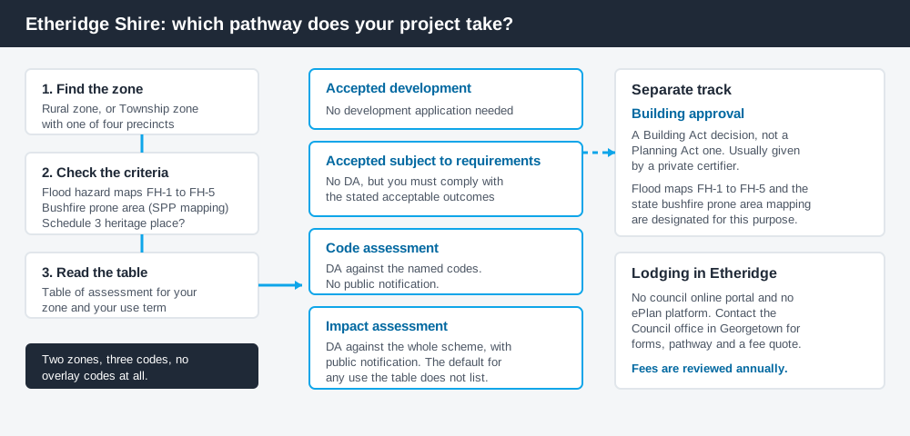
Figure 1: Two tracks run in parallel. Answering one does not answer the other.
The Etheridge Shire Planning Scheme
The scheme may be cited simply as the Etheridge Shire Planning Scheme. Adopted Version 1.1 records a notice published in the Government Gazette on 19 December 2025, and gives the commencement date as 1 December 2025. It replaces the scheme Council had run since 2020, so older advice may be out of step.
It follows the structure used across Queensland — strategic framework, tables of assessment, zones, codes, schedules — but Queensland schemes share that structure, not their content, and Etheridge's is unusually lean. There are two zones only: Rural, and Township, which carries four precincts — Commercial, Industrial, Residential and Rural Residential. A Georgetown industrial precinct is dealt with in the Rural zone code.
Three codes do the assessment work: General development, Operational work and Reconfiguring a lot. Four schedules follow — Definitions, Mapping, Etheridge Heritage Places, and an Aboriginal Cultural Significance Planning Scheme Policy. What zone your property is in is the first step in every enquiry here.
No overlays — the constraints sit in the tables and the maps
Spend 5 minutes, not 3 weeks
instantDA generates a council-ready planning report for Queensland development applications. No town planner. No waiting.
Get your report →Etheridge's scheme has no overlay codes at all. Where a city scheme would send you to a flood or bushfire overlay code, Etheridge writes the constraint into the assessment category criteria, then points at a map.
Flood runs through Schedule 2 as five maps: FH-1 covering the Queensland Floodplain Assessment Overlay for the whole shire, then FH-2 Georgetown, FH-3 Mount Surprise, FH-4 Forsayth and FH-5 Einasleigh. Council's strategic framework is candid that most of this is basic modelling, and that Georgetown alone has a detailed study behind it — a 2014 Level 2 study based on the 1974 event. The scheme notes a defined flood level for Georgetown of 297.01m AHD, and says the rest of the shire has none specified.
Bushfire works differently again: the scheme sends you to state SPP mapping, not to a council layer. Flood hazard overlays and bushfire hazard overlays explain how these layers behave.
Two approval tracks, not one
Development approval is a Planning Act 2016 decision. Council is the assessment manager, and it deals with land use, siting, scale and compliance with the scheme's assessment benchmarks.
Building approval is a Building Act decision about whether the structure complies with the building assessment provisions, usually given by a private certifier. Etheridge's scheme designates maps FH-1 to FH-5 and the state bushfire prone area mapping for building assessment purposes. Building approval versus development approval covers the distinction.
- ✓Rural or Township zone?
- ✓Which precinct?
- ✓Flood hazard area on FH-1 to FH-5?
- ✓Bushfire prone on SPP mapping?
- ✓Heritage place in Schedule 3?
- ✓Accepted, code or impact?
- ✓Building approval too?
Checking your own address
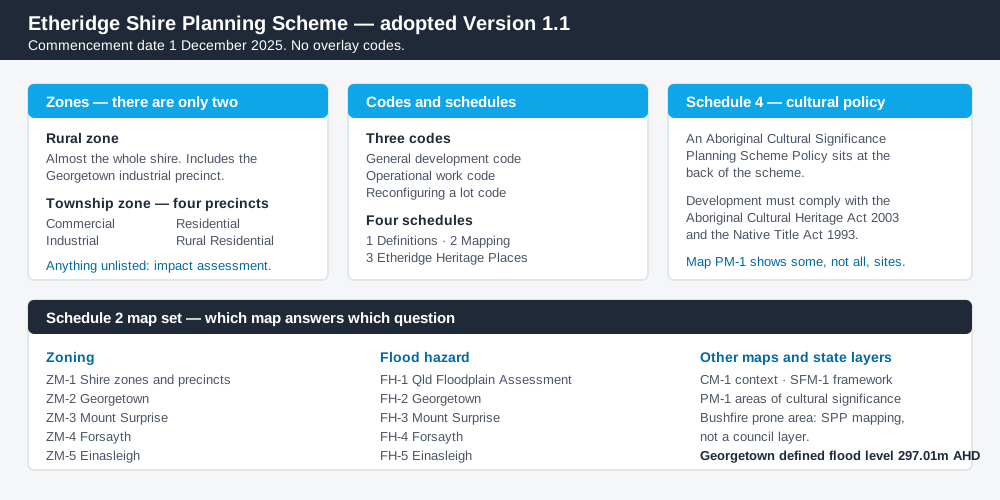
Figure 2: What the Etheridge scheme actually contains, and which map answers which question.
Etheridge does not run an ePlan platform or online development portal. Council publishes the adopted scheme as a PDF from its Planning Scheme page, and Schedule 2 holds the maps. Zoning comes from ZM-1 for the shire and ZM-2 to ZM-5 for the four townships. PM-1 shows areas of cultural significance near Georgetown.
For state layers — matters of state environmental significance, state-controlled roads, agricultural land classification and bushfire prone area — cross-check the site on the Queensland Globe.
What catches Etheridge owners out
Heritage places sit above everything. In both zone tables the accepted development list opens with a condition: the use is accepted only if it is not on a local heritage place identified in Schedule 3, unless Council is providing it. Schedule 3 lists real Georgetown addresses — the Shire Hall, the Anglican and Catholic churches, the Masonic Temple, the police station. Buy one and the easy pathway is gone. Heritage listings explains what that means.
The default is impact assessment. Each table ends with the same catch-all: any use not listed, any use failing the criteria, and any undefined use is impact assessable. In a two-zone scheme that does a lot of work, and impact assessment brings public notification with it. Accepted versus assessable development is worth reading first.
Tourism has numeric thresholds. A tourist park is accepted subject to requirements only where it is for 16 patrons or less per day and no more than four accommodation structures are built for overnight stays. Cross either number and you are in assessment. Short-stay accommodation covers the rest.
Rural does not mean unregulated. Cropping is accepted only at least 50m from any waterway; intensive animal industry is code assessable only at least 5km from the Township zone and 50m from a waterway. Building on rural land covers this.
When you will probably need a DA
Work that starts a new use, intensifies an existing one, reconfigures a lot, involves earthworks or clearing, or sits in a mapped flood hazard area or on a Schedule 3 heritage place is likely to be assessable. So is anything the tables do not name.
What to do next
Get the zone and precinct from the Schedule 2 zoning maps, check the matching flood map, then read the table of assessment for what you intend to do.
If you'd rather see the zone, the mapped constraints and the likely category of assessment for an Etheridge address in one place, an instantDA planning report does that for $169 — against the $800–$1,500 a town planner typically charges for a preliminary opinion. You can start a report in a few minutes.
Then call Council. In a shire this small a conversation with the office in St George Street, Georgetown beats any amount of reading — and since Council does not publish a development application fee schedule online, you need a quotation from them anyway.
Frequently asked questions
What is Etheridge Shire's planning scheme?
Are there overlays in the Etheridge planning scheme?
Can I lodge a development application online with Etheridge Shire Council?
How much does a development application cost in Etheridge Shire?
Does Aboriginal cultural heritage affect development in Etheridge?
Ready to generate your report?
Skip the writing. Get a council-ready planning report in 5 minutes.
Get your report