Key takeaways
- ✓Somerset's scheme is the Somerset Region Planning Scheme, now at Version 5.0, which commenced on 4 June 2026.
- ✓Council's eServices Property Enquiry and Interactive Mapping show the zone and overlays for an address.
- ✓The catchment management overlay protects the drinking water storages that supply South East Queensland.
- ✓Development approval and building approval are separate. One does not substitute for the other.
- ✓Somerset offers a free pre-lodgement service, which is unusually generous for a council of its size.
Do You Need Council Approval in Somerset?
You'll usually hear this called a development application, or DA — that's the formal name for council approval under the Planning Act 2016. In the Somerset region, Council is the assessment manager for most of them, and the rules it applies come from the Somerset Region Planning Scheme.
What makes Somerset distinctive is what sits inside it. Lake Wivenhoe and Lake Somerset supply drinking water to much of South East Queensland and buffer Brisbane against flooding downstream. Much of the region drains into them, and the scheme has a dedicated overlay to keep that water clean. Add rural land, the D'Aguilar Range and a string of Brisbane Valley towns, and you get a scheme where the overlay usually matters more than the zone.
Get a council-ready planning report in 5 minutes — no planner, no waiting.
Get your report →The short answer
In Somerset, you need a development application when the Somerset Region Planning Scheme makes the work assessable for your zone and overlays. Much minor domestic work on an unconstrained lot is accepted development. Building approval is separate, and is usually decided by a private certifier rather than Council.
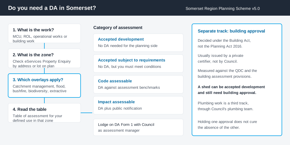
Figure 1: Two tracks run in parallel. One does not answer the other.
The Somerset Region Planning Scheme
Somerset's local planning scheme is the Somerset Region Planning Scheme. It came into force in 2016 and has been amended since rather than replaced. Council adopted Major Amendment 2 on 20 May 2026, and Version 5.0 commenced on 4 June 2026. Applications made from that date are assessed against Version 5.0; Version 4.2 is superseded. If you are working from a report or a downloaded PDF prepared before mid-2026, you may be reading a version that no longer applies.
Like every Queensland scheme, Somerset's follows the standardised state structure — strategic framework, zone codes, overlay codes and tables of assessment — with council-specific codes layered on top. Schemes are not uniform, so a rule from a neighbouring council does not carry across. How to find out what zone your property is in covers that structure.
Two approval tracks, not one
Spend 5 minutes, not 3 weeks
instantDA generates a council-ready planning report for Queensland development applications. No town planner. No waiting.
Get your report →This is the distinction that saves the most money, and the one most often missed in Somerset.
Development approval is a Planning Act 2016 decision. Council is the assessment manager, dealing with land use, siting, scale, lot layout and compliance with the scheme's codes. For a material change of use (MCU), reconfiguring a lot (ROL) or operational works, you apply on the state's DA Form 1.
Building approval is a Building Act decision about whether the structure complies with the building assessment provisions, measured against the QDC. It is usually given by a private certifier, not by Council.
A shed can be accepted development under the scheme and still need building approval, and holding a building approval does not cure a missing development approval. Building approval versus development approval covers this. Plumbing is a third track, through Council's plumbing team.
- ✓What is the zone?
- ✓Which overlays touch the lot?
- ✓Is the work accepted, code assessable or impact assessable?
- ✓If accepted, is it accepted subject to requirements?
- ✓Do you also need building approval?
Checking your own address
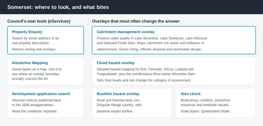
Figure 2: Council's tools, and the layers that change the answer.
Council does not run a branded ePlan viewer. Zone and overlay maps sit on its eServices site, across two tools.
Property Enquiry searches by street address or by lot on plan and returns the zoning of the allotment plus any overlays affecting it. Interactive Mapping puts the same layers on a map, which matters when you need to see how an overlay boundary crosses your land rather than whether it touches it.
The third tool is the development application search, also on eServices. Council has published decision notices back to the 2008 amalgamations, so you can see what has been approved nearby and read the conditions attached. On rural lots, that history beats the code text.
For state-administered layers, cross-check the site on the Queensland Globe.
What catches Somerset owners out
The catchment management overlay. This is the Somerset-specific one. It exists to stop development degrading water quality in the region's waterbodies — Lake Wivenhoe, Lake Somerset, Lake Atkinson and Splityard Creek Dam — and maps catchment risk areas plus watercourse setbacks. On a rural block it can drive where a dwelling sits, how effluent is treated and how stormwater is handled. Owners routinely find it after choosing a house site.
Flood. Detailed flood hazard mapping covers Esk, Fernvale, Kilcoy, Lowood and Toogoolawah, plus the mid-Brisbane River below Wivenhoe Dam. Floor levels and, for some work, the category of assessment follow from it. The flood hazard overlay explained covers how these work.
Bushfire. Rural and forested land, including D'Aguilar Range country, sits under bushfire hazard mapping with buffers. See the bushfire hazard overlay for what that means for siting and access.
Assuming a rural lot can be split. Rural residential subdivision pressure from Brisbane and Ipswich is real, but so are minimum lot sizes and catchment constraints. Reconfiguring a lot and building on rural land cover the traps.
When you will probably need a DA
Work that changes the use of a property, adds a dwelling, subdivides, or sits inside the catchment, flood or bushfire overlays is likely to be assessable. Tourism and short-stay proposals near the dams and the Brisbane Valley Rail Trail are anticipated in parts of the region, but anticipated is not exempt.
Minor domestic work on an unconstrained town lot is far more often accepted development, subject to any requirements attached to that acceptance. The reliable route is the table of assessment for your defined use, read against your zone and overlays.
What to do next
Run Property Enquiry for your address, list every overlay, then read the table of assessment for what you intend to do. Fees reset each financial year, so check the current figure before you budget.
If you'd rather see the zone, the overlays and the likely category of assessment for a Somerset address in one place, an instantDA planning report does that for $169 — against the $800–$1,500 a town planner typically charges for a preliminary opinion. You can start a report in a few minutes.
Then use Council's free pre-lodgement service. For anything touching the catchment overlay, flood mapping or a rural subdivision, that conversation is worth having before you pay a designer. Pre-lodgement meetings covers how to get value from one.
Frequently asked questions
What is Somerset's planning scheme?
How do I check the zoning of a Somerset property?
What is the catchment management overlay?
How much does a development application cost in Somerset?
Is building approval the same as council approval in Somerset?
Does Somerset offer pre-lodgement advice?
Ready to generate your report?
Skip the writing. Get a council-ready planning report in 5 minutes.
Get your report