Key takeaways
- ✓The current scheme is the Burdekin Shire Planning Scheme 2022, which commenced 1 March 2023 and replaced the 2011 IPA scheme.
- ✓There are eleven zones and seven overlay codes, but Council publishes eleven separate overlay maps — some constraints are mapped without a matching overlay code.
- ✓Council runs no interactive planning map. Zoning and overlays are read off PDF map sheets, so cross-check on Queensland Globe.
- ✓Applications are lodged on paper — two copies of plans plus an unlocked CD or USB. There is no online lodgement portal.
- ✓The rural zone is protected from fragmentation, which is why boundary realignments dominate Burdekin's application register.
Do You Need Council Approval in Burdekin Shire?
You'll usually hear this called a development application, or DA — that's the formal name for council approval under the Planning Act 2016. In Burdekin, Council is the assessment manager, and the rules it applies come from the Burdekin Shire Planning Scheme 2022.
Burdekin is a delta shire. Ayr and Home Hill sit on opposite banks of the Burdekin River, the towns are ringed by cane, and Council's own strategic framework says cane farming here is of national significance and that the shire's water allocations for irrigated agriculture underpin the regional economy. That shapes the scheme more than anything else.
In this guide: how the scheme is put together, the two approval tracks, how to check an address when there is no online map, and what catches Burdekin owners out.
Get a council-ready planning report in 5 minutes — no planner, no waiting.
Get your report →The short answer
In Burdekin Shire you need a development application when the Burdekin Shire Planning Scheme 2022 makes the work assessable for your zone or an overlay. Plenty of minor work in Ayr and Home Hill is accepted development. Building approval is separate, usually through a private certifier.
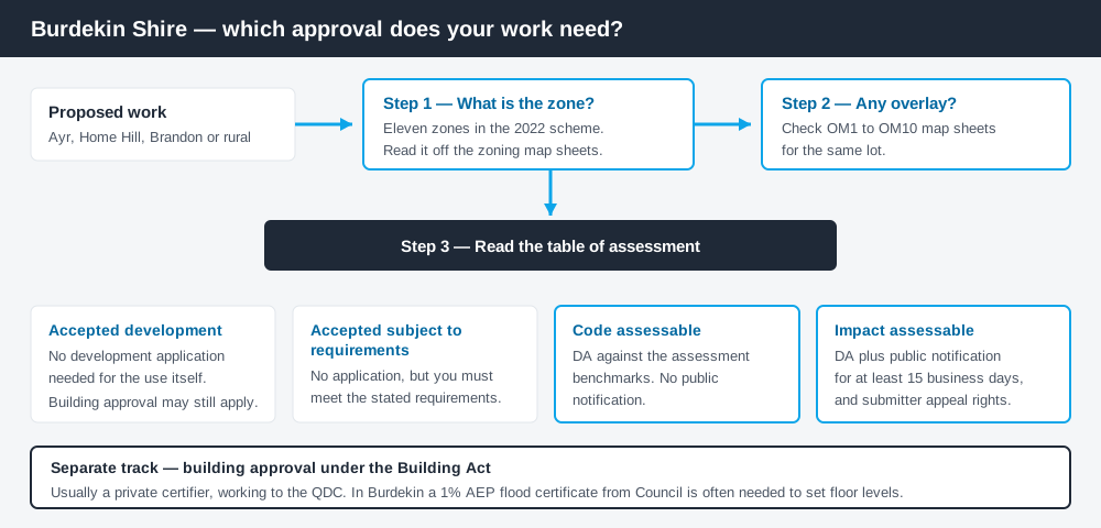
Figure 1: Two tracks run in parallel. Clearing one does not clear the other.
The Burdekin Shire Planning Scheme 2022
The scheme commenced on 1 March 2023, replacing the former Burdekin Shire IPA Planning Scheme of March 2011. Council publishes it as a single document dated December 2022, which is why you will sometimes see both years quoted.
Structurally it follows the standard Queensland pattern — strategic framework, zones, overlays, development codes, definitions. Queensland schemes share that structure, not their content, so the detail here is Burdekin's own. There are eleven zones: Centre, Community facilities, Emerging community, Environmental management and conservation, Industry, Low density residential, Low-medium density residential, Recreation and open space, Rural, Rural residential and Township. Two development codes sit behind them — Development works, and Reconfiguring a lot. Working out what zone your property is in is the first step.
Overlays — and a mapping quirk worth knowing
Spend 5 minutes, not 3 weeks
instantDA generates a council-ready planning report for Queensland development applications. No town planner. No waiting.
Get your report →Part 5 contains seven overlay codes: bushfire hazard, coastal hazard, environmental significance, extractive resources, flood hazard, heritage and regional infrastructure. But Council publishes eleven overlay map sheets, numbered OM1 to OM10, and three — acid sulfate soils, agricultural land and transport noise corridor — have no matching overlay code. Those constraints are still real; they are picked up through the strategic framework, the development codes or state provisions instead.
That distinction trips people up: being clear of the overlay codes is not the same as being clear of the maps. Flood alone is split across two sheets — OM7a covers river flood hazard, OM7b local rain events. Flood hazard overlays and acid sulfate soils both bite hard on delta land, where excavation can disturb sulfidic soils or lift the water table.
Two approval tracks, not one
Development approval is a Planning Act 2016 decision. Council is the assessment manager, and it deals with land use, siting, scale and whether the proposal meets the relevant assessment benchmarks.
Building approval is a Building Act decision about whether the structure complies with the building assessment provisions, normally given by a private certifier working to the QDC. Burdekin adds a step: Council issues 1% AEP flood certificates, which a certifier or designer will often need before setting floor levels. Building approval versus development approval explains where the line falls.
- ✓Which of the eleven zones?
- ✓On OM7a or OM7b flood mapping?
- ✓Inside the coastal overlay OM4?
- ✓Acid sulfate soils on OM1?
- ✓Accepted, or assessable?
- ✓Building approval and a flood certificate too?
Checking your own address
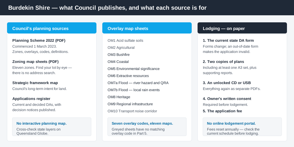
Figure 2: What Burdekin publishes, and what each source is actually for.
Burdekin does not run an interactive planning map. There is no ePlan platform and no address search that returns your zone. Council publishes the scheme, a zoning map PDF and the overlay map sheets as downloads, and you read your property off them. Council's Community Maps page carries town and road maps only — it is not a planning tool.
Practically: download the zoning maps, find your lot, work through OM1 to OM10 for the same location, then cross-check the state layers on the Queensland Globe. The Queensland Globe guide covers that second step.
Lodgement is paper too. Council requires the current state DA form, two copies of plans including at least one A3 set, an unlocked CD or USB with everything as separate PDFs, and the fee. DA Form 1 covers the form itself.
What catches Burdekin owners out
Rural fragmentation. The scheme protects rural-zoned land from subdivision below the minimum lot size in the zone code, with narrow exceptions — consolidating a farmed balance of at least 30 hectares around a pre-existing dwelling house, or rearranging boundaries in a way that clearly improves land management without creating another lot. Read Council's application register and the effect is obvious: boundary realignments heavily outnumber genuine subdivisions. Boundary realignments is the guide most Burdekin landholders need.
Good agricultural land. Class A and B agricultural land classification areas and priority agricultural areas are protected from encroachment by uses that could reduce production. A shed or second dwelling on cane country is not automatically a problem, but it is assessed against that intent. Building on rural land sets out the approach.
Water and storm tide. Alva, part of Giru, Groper Creek, Jerona and Wunjunga are exposed to storm tide surge and coastal erosion, and Ayr, Home Hill, Brandon, Clare, Giru, Groper Creek, Inkerman and Jerona all carry significant flood risk. Storm tide and coastal hazard matters near the coast.
When you will probably need a DA
Work that starts a new use, re-establishes an abandoned one, or increases the scale or intensity of an existing one is a material change of use. Subdividing, amalgamating or realigning boundaries is reconfiguring a lot. Filling, excavating, car parks and stormwater works are operational works. Layer a flood, coastal or acid sulfate soils constraint over any of those and the category of assessment usually shifts upward.
Modest work in Ayr or Home Hill on an unconstrained residential lot is far more often accepted development.
What to do next
Get your zone off the zoning map sheets, check the same lot against every overlay map, then read the table of assessment for what you intend to do.
If you'd rather see the zone, the mapped constraints and the likely category of assessment for a Burdekin address in one place, an instantDA planning report does that for $169 — against the $800–$1,500 a town planner typically charges for a preliminary opinion. You can start a report in a few minutes.
Then talk to Council. Fees change annually and are deliberately not quoted here; get the current figure before you lodge. Council's Development Applications page has the lodgement requirements, both fee links and the register of current and decided applications.
Frequently asked questions
What is Burdekin Shire's planning scheme?
Does Burdekin Shire have an online planning map?
How do I lodge a development application in Burdekin?
How much does a development application cost in Burdekin?
Why are there so many boundary realignments in Burdekin?
Ready to generate your report?
Skip the writing. Get a council-ready planning report in 5 minutes.
Get your report